NY 27
| New York State Route 27 | ||||
|---|---|---|---|---|

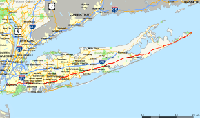
Map of Long Island with NY 27 highlighted in red
|
||||
| Route information | ||||
| Maintained by NYSDOT, NYCDOT and Suffolk County | ||||
| Length: | 120.58 mi (194.05 km) | |||
| Existed: | mid-1920s – present | |||
| Major junctions | ||||
| West end: |
|
|||
|
|
||||
| East end: | Montauk Point State Park in Montauk | |||
| Location | ||||
| Counties: | Kings, Queens, Nassau, Suffolk | |||
| Highway system | ||||
|
||||
New York State Route 27 (NY 27) is an east–west 120.58-mile (194.05 km) long state highway extending from Interstate 278 (I-278) in the New York City borough of Brooklyn to Montauk Point State Park on Long Island, New York, in the United States. Its two most prominent components are Sunrise Highway and Montauk Highway, the latter of which includes the Montauk Point State Parkway. East of the interchange with the Heckscher State Parkway in Islip Terrace, NY 27 acts as the primary east–west highway on southern Long Island. The entire route in Suffolk, Nassau, and Queens counties was designated by the New York State Senate as the POW/MIA Memorial Highway. Every town on the South Shore is accessible through Sunrise Highway. The service roads that parallel the highway from Farmingdale to Brookhaven are officially designated, but not signed, as New York State Route 906C and New York State Route 906D.
NY 27 begins at exit 24 of I-278 (the Gowanus Expressway) in the borough of Brooklyn in New York City. For the first stretch through Brooklyn, NY 27 runs along the Prospect Expressway, a sunken six-lane freeway through the Park Slope and Windsor Terrace neighborhood, providing interchanges with Fourth Avenue, Seventh Avenue and 11th Avenue. At exit 5, the expressway interchanges with Ocean and Fort Hamilton Parkways before ending a short distance to the south at exit 6 and Church Avenue.
...
Wikipedia

