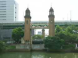
Nakagawa-ku, Nagoya
|
Nakagawa 中川区 |
|
|---|---|
| Ward | |
| Nakagawa Ward | |

Matsushige Rock Gate
|
|
 Location of Nakagawa in Aichi Prefecture |
|
| Location in Japan | |
| Coordinates: 35°8′30″N 136°51′18″E / 35.14167°N 136.85500°ECoordinates: 35°8′30″N 136°51′18″E / 35.14167°N 136.85500°E | |
| Country | Japan |
| Region |
Chūbu region Tōkai region |
| Prefecture | Aichi Prefecture |
| Area | |
| • Total | 32.03 km2 (12.37 sq mi) |
| Population (September 2011) | |
| • Total | 221,751 |
| • Density | 6,909/km2 (17,890/sq mi) |
| Symbols | |
| • Tree | Japanese Black Pine |
| • Flower | Ornamental cabbage |
| Time zone | Japan Standard Time (UTC+9) |
| City hall address | 愛知県名古屋市中川区高畑一丁目223 454-8501 |
| Website |
www |
Nakagawa (中川区 nakagawaku?) is one of the 16 wards of the city of Nagoya in Aichi Prefecture, Japan.
...
Wikipedia

