Naucalpan
| Naucalpan de Juárez | |||
|---|---|---|---|
| City & Municipality | |||
| Naucalpan de Juárez | |||

Torres de Satélite sculpture
|
|||
|
|||
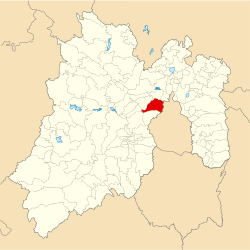
 Location of Naucalpan in the State of Mexico |
|||
| Coordinates: 19°28′31″N 99°14′16″W / 19.47528°N 99.23778°W | |||
| Country |
|
||
| State |
|
||
| Region | Naucalpan | ||
| Metro area | Greater Mexico City | ||
| Municipal Status | January 1, 1826 | ||
| Municipal Seat | Naucalpan de Juárez | ||
| Government | |||
| • Type | Ayuntamiento | ||
| • Municipal President | Edgar Armando Olvera Higuera | ||
| Area | |||
| • Municipality | 156.63 km2 (60.48 sq mi) | ||
| • Water | 1.56 km2 (0.60 sq mi) | ||
| Elevation (of seat) | 2,300 m (7,500 ft) | ||
| Population (2010 Census) | |||
| • Municipality | 833,779 | ||
| Time zone | CST (UTC-6) | ||
| • Summer (DST) | CDT (UTC-5) | ||
| Postal code (of seat) | 53000 | ||
| Area code(s) | 55 | ||
| Demonym | Naucalpense | ||
| Website | Official website (Spanish) | ||
Naucalpan, officially Naucalpan de Juárez, is a city and municipality located just northwest of Mexico City in adjoining State of Mexico. The name Naucalpan comes from Nahuatl and means “place of the four neighborhoods or four houses. “de Juárez was added to the official name in 1874 in honor of Benito Juárez. The history of the area begins with the Tlatilica who settled on the edges of the Hondo River between 1700 and 600 B.C.E., but it was the Aztecs who gave it its current name when they dominated it from the 15th century until the Spanish conquest of the Aztec Empire. Naucalpan claims to be the area where Hernán Cortés rested on the “Noche Triste” as they fled Tenochtitlan in 1520, but this is disputed. It is the home of the Virgin of Los Remedios, a small image of the Virgin Mary which is strongly associated with the Conquest and is said to have been left here. Today, the city of Naucalpan is actually larger than the municipality itself, with part of it extending into neighboring Huixquilucan Municipality. It is a major center of industry in Mexico. It is, however, best known as the location of Ciudad Satélite, a development from the 1960s and the site of the Toreo de Cuatro Caminos bullring, which was recently demolished. The only unurbanized areas of the municipality are the Los Remedios National Park and a number of ejidos, however, the lack of housing has put serious pressure on these areas.
...
Wikipedia


