Nayemont-les-Fosses
| Nayemont-les-Fosses | |
|---|---|
| Commune | |

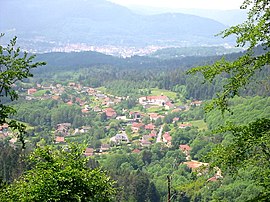
View of Nayemont-les-Fosses, with Saint-Dié-des-Vosges in the background
|
|
| Coordinates: 48°17′51″N 7°00′25″E / 48.2975°N 7.0069°ECoordinates: 48°17′51″N 7°00′25″E / 48.2975°N 7.0069°E | |
| Country | France |
| Region | Grand Est |
| Department | Vosges |
| Arrondissement | Saint-Dié-des-Vosges |
| Canton | Saint-Dié-des-Vosges-2 |
| Intercommunality | CA Saint-Dié-des-Vosges |
| Government | |
| • Mayor (2001–2008–2014) | Patrice Fève |
| Area1 | 8.91 km2 (3.44 sq mi) |
| Population (2006)2 | 923 |
| • Density | 100/km2 (270/sq mi) |
| Time zone | CET (UTC+1) |
| • Summer (DST) | CEST (UTC+2) |
| INSEE/Postal code | 88320 /88100 |
| Elevation | 345–890 m (1,132–2,920 ft) (avg. 500 m or 1,600 ft) |
|
1 French Land Register data, which excludes lakes, ponds, glaciers > 1 km² (0.386 sq mi or 247 acres) and river estuaries. 2Population without double counting: residents of multiple communes (e.g., students and military personnel) only counted once. |
|
1 French Land Register data, which excludes lakes, ponds, glaciers > 1 km² (0.386 sq mi or 247 acres) and river estuaries.
Nayemont-les-Fosses is a commune in the Vosges department in Grand Est in northeastern France.
Inhabitants are called Nayemontais.
The commune is adjacent to Saint-Dié-des-Vosges, on its eastern side, and on the sunny side of the . The commune's territory extends to the right bank of the little . The mountain topography enforces a somewhat dispersed layout for the commune's settlements, which include both the village of Nayemont itself and various hamlets such as Brompont, les Basses Fosses, les Hautes Fosses and Menumont.
Archaeological discoveries indicate significant human presence here both during the later Neolithic period and subsequently. Presumably the district shared in the switch from a nomadic hunting existence to one involving settlement and agriculture. Presumably, too, the area had its share of fighting and conquest.
During the first millennium, the end of the Gallo-Roman period was accompanied by the disappearance of central authority. It was a troubled period for Lorraine, characterised by wars and the disappearances - presumably following violent assaults - of settled communities. However, the construction on the hill a little to the east of the present day village, of Spitzemberg Castle around 900 indicates an attempt to achieve greater permanence amid the ruins of the Gallo-Roman civilisation. During the Hungarian invasions castles such as this provided a refuge for threatened villagers.
The Lordship of Spitzemberg fell within the Duchy of Lorraine, created in 959 by the German Emperor, Otto I. Lorraine remained subject to the German emperors until the early fifteenth century which ushered in several uncomfortable centuries during which Lorraine would find itself one of several buffer states lodged between the conflicting territorial ambitions of The Empire and of France.
...
Wikipedia


