Nevada State Route 156
| State Route 156 | ||||
|---|---|---|---|---|
| Lee Canyon Road | ||||

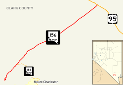
Nevada State Route 156, highlighted in red
|
||||
| Route information | ||||
| Maintained by NDOT | ||||
| Length: | 17.592 mi (28.312 km) | |||
| Existed: | 1976 – present | |||
| Major junctions | ||||
| West end: | Lee Canyon | |||
| East end: |
|
|||
| Location | ||||
| Counties: | Clark | |||
| Highway system | ||||
|
||||
State Route 156 (SR 156), also known as Lee Canyon Road, is a state highway in Clark County, Nevada. The road is one of two highways connecting U.S. Route 95 (US 95) to the Humboldt-Toiyabe National Forest and Spring Mountains area northwest of Las Vegas, and its entire length is designated a Nevada Scenic Byway.
When first created in the 1930s, the highway followed a slightly different path that formed State Route 52. The SR 52 designation was later realigned and extended west to the California state line via Pahrump, but was discontinuous through the national forest. The route was ultimately split into separate highways in the 1970s.
The road now known as State Route 156 has origins dating to at least 1933. At that time, it was an unimproved county road that ran from State Route 5 (now US 95) at Indian Springs to the northern border of what was then called the Nevada National Forest. By 1935, this road had been designated as State Route 52, and apparently extended through the national forest (along what may now be State Route 158) ending at State Route 39 (now SR 157) east of Charleston Peak.
...
Wikipedia

