New Boston, Texas
| New Boston, Texas | |
|---|---|
| City | |
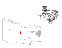
 Location of New Boston, Texas |
|
 |
|
| Coordinates: 33°27′38″N 94°25′2″W / 33.46056°N 94.41722°WCoordinates: 33°27′38″N 94°25′2″W / 33.46056°N 94.41722°W | |
| Country | United States |
| State | Texas |
| County | Bowie |
| Area | |
| • Total | 3.3 sq mi (8.5 km2) |
| • Land | 3.3 sq mi (8.5 km2) |
| • Water | 0.0 sq mi (0.0 km2) |
| Elevation | 358 ft (109 m) |
| Population (2010) | |
| • Total | 4,550 |
| • Density | 1,383/sq mi (534.0/km2) |
| Time zone | Central (CST) (UTC-6) |
| • Summer (DST) | CDT (UTC-5) |
| ZIP code | 75570 |
| Area code(s) | 903 |
| FIPS code | 48-50808 |
| GNIS feature ID | 1363692 |
| Website | www |
New Boston is a city in Bowie County, Texas, United States. It was named after an early store keeper, W.J. Boston. It is part of the Texarkana, Texas - Texarkana, Arkansas Metropolitan Statistical Area. The population was 4,550 at the 2010 census.
New Boston is located near the center of Bowie County at 33°27′38″N 94°25′2″W / 33.46056°N 94.41722°W (33.460551, -94.417246).U.S. Route 82 passes through the center of the city, and Interstate 30 runs through the northern part of the city, with access from Exits 199 and 201. By either route it is 22 miles (35 km) east to Texarkana. I-30 leads southwest 40 miles (64 km) to Mount Pleasant, and US 82 leads west-northwest 70 miles (110 km) to Paris. Texas State Highway 8 leads south 4 miles (6.4 km) to Old Boston, the site of original town settlement in the 1800s, and north 7 miles (11 km) to the Red River and the border with the state of Arkansas. The Red River Army Depot borders the southeastern edge of New Boston.
According to the United States Census Bureau, the city has a total area of 3.3 square miles (8.5 km2), all of it land.
...
Wikipedia
