New York State Route 38
| New York State Route 38 | ||||
|---|---|---|---|---|

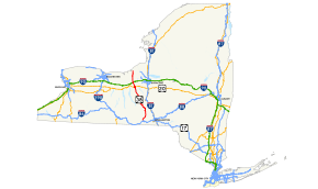
Map of New York with NY 38 highlighted in red
|
||||
| Route information | ||||
| Maintained by NYSDOT and the city of Auburn | ||||
| Length: | 95.65 mi (153.93 km) | |||
| Existed: | 1930 – present | |||
| Major junctions | ||||
| South end: |
|
|||
|
|
||||
| North end: |
|
|||
| Location | ||||
| Counties: | Tioga, Cortland, Tompkins, Cayuga | |||
| Highway system | ||||
|
||||
| New York State Route 38B | |
|---|---|
| Location: | Newark Valley–Maine |
| Length: | 7.69 mi (12.38 km) |
New York State Route 38 (NY 38) is a north–south state highway in the Finger Lakes region of New York in the United States. Its southern terminus is at an intersection with NY 96 in the town of Owego in Tioga County. The northern terminus is at a junction with NY 104A in the town of Sterling in Cayuga County. NY 38 is a two-lane local road for most of its length. The route is the main access road to parts of Auburn, Dryden, Newark Valley and Port Byron. It passes through mountainous terrain in Tioga and Cortland counties, but the terrain levels out as it heads through the Finger Lakes area and Cayuga County.
The route intersects several long-distance highways, including NY 13 in Dryden, U.S. Route 20 (US 20) and NY 5 in Auburn, and NY 31 in Port Byron. It passes over the New York State Thruway (Interstate 90 or I-90) north of Port Byron; however, there is no connection between the two. NY 38 has two suffixed routes. The first, NY 38A is an alternate route of NY 38 between Moravia and Auburn, while the other, NY 38B, is a simple east–west connector in the Southern Tier. While NY 38 runs along the western shore of Owasco Lake, NY 38A travels to Auburn along a routing east of the lake.
...
Wikipedia

