Noatak, Alaska
|
Noatak Nuataaq |
|
|---|---|
| CDP | |

Gravel extraction in Noatak village
|
|
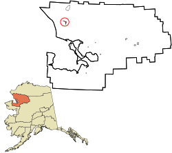
 Location in Northwest Arctic Borough and the state of Alaska. |
|
| Coordinates: 67°34′19″N 162°58′30″W / 67.57194°N 162.97500°WCoordinates: 67°34′19″N 162°58′30″W / 67.57194°N 162.97500°W | |
| Country | United States |
| State | Alaska |
| Borough | Northwest Arctic |
| Government | |
| • Borough mayor | Clement Richards, Sr. |
| • State senator | Donny Olson (D) |
| • State rep. | Dean Westlake (D) |
| Area | |
| • Total | 12.2 sq mi (31.7 km2) |
| • Land | 11.6 sq mi (29.9 km2) |
| • Water | 0.7 sq mi (1.7 km2) |
| Population (2010) | |
| • Total | 514 |
| • Density | 42/sq mi (16/km2) |
| Time zone | Alaska (AKST) (UTC-9) |
| • Summer (DST) | AKDT (UTC-8) |
| ZIP code | 99761 |
| Area code(s) | 907 |
| FIPS code | 02-54700 |
Noatak (Nuataaq in Iñupiaq) is a census-designated place (CDP) in the Northwest Arctic Borough in the U.S. state of Alaska. The population was 514 at the 2010 census. It is served by Noatak Airport.
Noatak was established as a fishing and hunting camp in the 1800s. Two identifiable groups of Inupiat resided on the Noatak River. The Nautaagmiut (called "Noatagamut" in the 1880 census), Inupiaq for "inland river people", lived upriver, and the Napaaqtugmiut, meaning "people of the trees", lived downriver. By the early 20th century, the missionaries Robert and Carrie Samms settled in what they called "Noatak". A United States post office was established in 1940.
Noatak is located at 67°34′19″N 162°58′30″W / 67.57194°N 162.97500°W (67.572031, -162.975085).
Noatak is located on the west bank of the Noatak River, 81 km (50 mi) north of Kotzebue. It is 102 km (63 mi) north of the Arctic Circle. Noatak village lies near the western boundary of the 6.6-million acre (270,000 km2) Noatak National Preserve and is the only settlement on the over-400-mile (640 km) long Noatak River.
...
Wikipedia
