North Haven, Maine
| North Haven, Maine | |
|---|---|
| Town | |

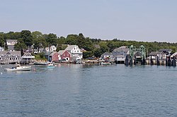
Harborfront and ferry terminal, 2005
|
|
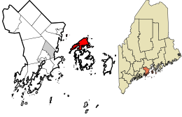
 Location in Knox County and the state of Maine. |
|
| Coordinates: 44°9′15″N 68°52′41″W / 44.15417°N 68.87806°W | |
| Country | United States |
| State | Maine |
| County | Knox |
| Incorporated | 1846 |
| Area | |
| • Total | 82.49 sq mi (213.65 km2) |
| • Land | 11.62 sq mi (30.10 km2) |
| • Water | 70.87 sq mi (183.55 km2) |
| Elevation | 0 ft (0 m) |
| Population (2010) | |
| • Total | 355 |
| • Estimate (2012) | 352 |
| • Density | 30.6/sq mi (11.8/km2) |
| Time zone | Eastern (EST) (UTC-5) |
| • Summer (DST) | EDT (UTC-4) |
| ZIP code | 04853 |
| Area code(s) | 207 |
| FIPS code | 23-51620 |
| GNIS feature ID | 0582633 |
North Haven is a town in Knox County, Maine, United States, in Penobscot Bay. The town is both a year-round island community and a prominent summer colony. The population was 355 at the 2010 census. North Haven is accessed by three-times daily ferry service from Rockland, or by air taxi from Knox County Regional Airport.
As early as 3300 BC, the island was visited by the Red Paint People. Later it became part of the territory of the Penobscot Abenaki Indians, who hunted and fished in canoes along the coast. Captain Martin Pring, the explorer from Bristol, England, "discovered" North Haven and Vinalhaven in 1603. He called them the Fox Islands, a name which survives on the Fox Islands Thoroughfare, a mile-wide strait separating the towns which provides passage for boats crossing Penobscot Bay.
Settled in the 1760s, North Haven was originally the North Island of Vinalhaven, from which it was set off and incorporated on June 30, 1846 as Fox Isle. It was changed to North Haven on July 13, 1847. An act was passed by the state legislature in 1850 which gave the majority of island inhabitants "the right to have such roads as they deemed fit." The majority thereupon decided to have no roads at all, or else roads obstructed with gates or bars at the discretion of landowners. Not surprisingly, the minority of inhabitants petitioned to amend the act.
...
Wikipedia
