Northern Liberties, Philadelphia, Pennsylvania
| Northern Liberties District | |
| Former District | |
| Country | United States |
|---|---|
| State | Pennsylvania |
| County | Philadelphia |
| Coordinates | 39°57′47″N 75°08′42″W / 39.96306°N 75.14500°WCoordinates: 39°57′47″N 75°08′42″W / 39.96306°N 75.14500°W |
| Timezone | EST (UTC-5) |
| - summer (DST) | EDT (UTC-4) |
| Area code | 215 |
|
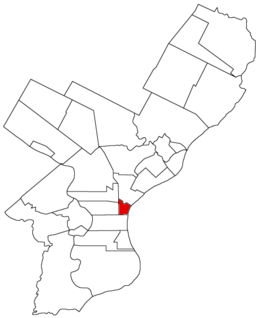
Map of Philadelphia County, Pennsylvania highlighting Northern Liberties District prior to the Act of Consolidation, 1854
|
|
|
Northern Liberties Historic District
|
|

Houses on North 5th Street
|
|
| Location | Roughly bounded by Brown, Boone & Galloway, Green & Wallace, and Fifth & Sixth Sts. Philadelphia, Pennsylvania |
|---|---|
| Coordinates | 39°57′47″N 75°08′42″W / 39.96306°N 75.14500°W |
| Area | 20.5 acres (8.3 ha) |
| Built | 1791 |
| Architect | Unknown |
| Architectural style | Greek Revival, Italianate, Federal |
| NRHP Reference # | 85003471 |
| Added to NRHP | October 31, 1985 |
Northern Liberties is a neighborhood in Philadelphia, Pennsylvania, United States.
Northern Liberties is located north of Center City (specifically, Old City) and is bordered by Girard Avenue to the north; Callowhill Street to the south; North 6th Street to the west; and the Delaware River to the east (from Callowhill Street to Laurel Street; from Laurel Street to Girard Avenue the eastern boundary is North Front Street). The historical boundaries were slightly different, with Vine Street as the southern border and the Cohocksink Creek serving as the northern border. The creek now flows as a storm sewer under the following streets (starting at the Delaware River and running from southeast to northwest): Canal, Laurel, Bodine, Cambridge, and Orkney Streets.
Originally a portion of the Northern Liberties Township, the district first gained limited autonomy from the township by an Act of Assembly on March 9, 1771. The Act provided for the appointment of persons to regulate streets, direction of buildings, etc. By March 30, 1791 a second Act enabled the inhabitants of that portion of the Northern Liberties between Vine Street and Pegg’s Run (Cohoquinoque Creek) and the middle of Fourth Street and the Delaware River to elect three commissioners to lay taxes for the purpose of lighting, watching and establishing pumps within those bounds.
During the Yellow Fever epidemics of the late eighteenth and early nineteenth centuries, the Northern Liberties district was hard hit, with many fatalities.
On March 28, 1803, the Legislature passed an act to incorporate that part of the township of the Northern Liberties lying between the west side of Sixth Street and the Delaware River and between Vine Street and Cohocksink Creek, thus creating the District of Northern Liberties. Under the Act of Consolidation, 1854, the district ceased to exist, and became a part of Philadelphia.
...
Wikipedia


