Northrepps
| Northrepps | |
|---|---|
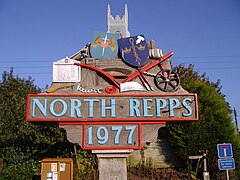
 The village sign |
|
| Northrepps shown within Norfolk | |
| Area | 10.65 km2 (4.11 sq mi) |
| Population | 886 (parish, 2011 census) |
| • Density | 83/km2 (210/sq mi) |
| OS grid reference | TG245395 |
| • London | 136 miles |
| Civil parish |
|
| District | |
| Shire county | |
| Region | |
| Country | England |
| Sovereign state | United Kingdom |
| Post town | CROMER |
| Postcode district | NR27 |
| Dialling code | 01263 |
| Police | Norfolk |
| Fire | Norfolk |
| Ambulance | East of England |
| EU Parliament | East of England |
| UK Parliament | |
Northrepps is a village and a civil parish in the English county of Norfolk. It is 3.4 miles (5.5 km) southeast of Cromer, 22.2 miles (35.7 km) north of Norwich and 137 miles (220 km) north of London. The village lies west of the A149 which runs between Kings Lynn and Great Yarmouth. The nearest railway station is at Cromer for the Bittern Line which runs between Sheringham, Cromer and Norwich. The nearest airport is Norwich International Airport. The village and parish of Northrepps had in the 2001 census a population of 839, increasing to 886 at the 2011 Census. For the purposes of local government, the village falls within the district of North Norfolk.
The parish of Northrepps was reduced in size in 1906, losing land to the parish of Overstrand which lies to the north. The parish boundary to the north-west is with Cromer, to the north-east with Sidestrand. To the west are the boundaries with Felbrigg and Roughton whilst to the south is the parish of Southrepps. At its nearest point the parish is just 500 metres from the coast on the north-eastern boundary, which partly follows the course of the disused Norfolk and Suffolk Joint Railway between Cromer and North Walsham, which closed in 1953. Also in the north of the parish is Cottage Wood, which is largely given over to the Forest Park Caravan Site. In the south east of the parish there is more woodland known as Fox Hills, bounded around its south-west edge by the Paston Way footpath. The Bittern Line railway cuts through the western section of the parish. The landscape of the parish is largely arable farmland made up of low hills and valleys; the soil is light and very sandy and the subsoil gravel. The parish contains the village of Northrepps as well as Frogshall, which is in Fox Hills, and Crossdale Street, which straddles the A149 in the west of the parish. The A140 begins at a junction with the A149 within the parish. The name Northrepps is derived from the Old English word repel, meaning strips of land in a fen that can be tilled.
...
Wikipedia

