Northumberland, New Hampshire
| Northumberland, New Hampshire | |
|---|---|
| Town | |

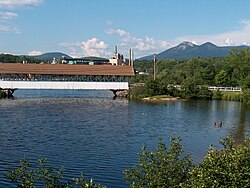
Covered bridge over the Upper Ammonoosuc River
|
|
 Location in Coos County, New Hampshire |
|
| Coordinates: 44°33′48″N 71°33′31″W / 44.56333°N 71.55861°WCoordinates: 44°33′48″N 71°33′31″W / 44.56333°N 71.55861°W | |
| Country | United States |
| State | New Hampshire |
| County | Coos |
| Incorporated | 1779 |
| Government | |
| • Board of Selectmen | James Weagle, Chair Michael Phillips James Tierney, Jr. |
| Area | |
| • Total | 36.5 sq mi (94.5 km2) |
| • Land | 35.7 sq mi (92.5 km2) |
| • Water | 0.8 sq mi (2.0 km2) 2.13% |
| Elevation | 860 ft (262 m) |
| Population (2010) | |
| • Total | 2,288 |
| • Density | 63/sq mi (24/km2) |
| Time zone | Eastern (UTC-5) |
| • Summer (DST) | Eastern (UTC-4) |
| ZIP codes | 03582, 03583 |
| Area code(s) | 603 |
| FIPS code | 33-56100 |
| GNIS feature ID | 0873688 |
| Website | northumberlandnh |
Northumberland is a town located in southwestern Coos County, New Hampshire, U.S., north of Lancaster. It is part of the Berlin, NH–VT micropolitan statistical area. As of the 2010 census, the town population was 2,288, a large portion in the village of Groveton.
North of the mountain ridge known as Cape Horn, near the Connecticut River, are the remains of Fort Wentworth, built by the New Hampshire Militia in 1755 during the French and Indian War. The town was granted as Stonington in 1761 to John Hogg and others by Governor Benning Wentworth, and first settled in 1767 by Thomas Burnside and Daniel Spaulding. It was regranted by Governor John Wentworth in 1771 as Northumberland, the name derived from Northumberland in England. The town was incorporated November 16, 1779.
Groveton is the northern terminus of a railroad track owned by the New Hampshire & Vermont Railroad, where it intersects the St. Lawrence & Atlantic Railroad. This was formerly the junction of the Grand Trunk Railway and the Boston, Concord & Montreal Railroad—a major point of access for the northern White Mountains.
...
Wikipedia
