Northvale, New Jersey
| Northvale, New Jersey | |
|---|---|
| Borough | |
| Borough of Northvale | |

|
|
 Map highlighting Northvale's location within Bergen County. Inset: Bergen County's location within New Jersey. |
|
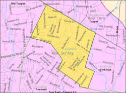
 Census Bureau map of Northvale, New Jersey |
|
| Coordinates: 41°00′47″N 73°56′53″W / 41.013°N 73.948085°WCoordinates: 41°00′47″N 73°56′53″W / 41.013°N 73.948085°W | |
| Country | |
| State |
|
| County | Bergen |
| Incorporated | March 15, 1916 |
| Government | |
| • Type | Borough |
| • Body | Borough Council |
| • Mayor | Stanley E. "Ed" Piehler (term ends December 31, 2018) |
| • Clerk | Wanda A. Worner |
| Area | |
| • Total | 1.298 sq mi (3.362 km2) |
| • Land | 1.295 sq mi (3.355 km2) |
| • Water | 0.003 sq mi (0.007 km2) 0.20% |
| Area rank | 472nd of 566 in state 59th of 70 in county |
| Elevation | 46 ft (14 m) |
| Population (2010 Census) | |
| • Total | 4,640 |
| • Estimate (2015) | 4,859 |
| • Rank | 390th of 566 in state 62nd of 70 in county |
| • Density | 3,582.3/sq mi (1,383.1/km2) |
| • Density rank | 177th of 566 in state 37th of 70 in county |
| Time zone | Eastern (EST) (UTC-5) |
| • Summer (DST) | Eastern (EDT) (UTC-4) |
| ZIP code | 07647 |
| Area code(s) | 201 exchanges: 750, 767, 768, 784 |
| FIPS code | 3400353430 |
| GNIS feature ID | 0885327 |
| Website | www |
Northvale is a borough in Bergen County, New Jersey, United States. As of the 2010 United States Census, the borough's population was 4,640, reflecting an increase of 180 (+4.0%) from the 4,460 counted in the 2000 Census, which had in turn declined by 103 (-2.3%) from the 4,563 counted in the 1990 Census.
The borough of Northvale was formed on March 15, 1916, from the remaining portions of Harrington Township, based on the results of a referendum held on April 4, 1916. With the creation of Northvale, Harrington Township was dissolved. Portions of Northvale were transferred to create the borough of Rockleigh, as of March 13, 1923. The borough's name derives from its location and topography.
According to the United States Census Bureau, the borough had a total area of 1.298 square miles (3.362 km2), including 1.295 square miles (3.355 km2) of land and 0.003 square miles (0.007 km2) of water (0.20%).
The borough borders Norwood, Old Tappan and Rockleigh in Bergen County and Tappan (in the Town of Orangetown) in Rockland County, New York.
As of the 2010 United States Census, there were 4,640 people, 1,564 households, and 1,265 families residing in the borough. The population density was 3,582.3 per square mile (1,383.1/km2). There were 1,635 housing units at an average density of 1,262.3 per square mile (487.4/km2). The racial makeup of the borough was 71.94% (3,338) White, 1.06% (49) Black or African American, 0.19% (9) Native American, 24.01% (1,114) Asian, 0.02% (1) Pacific Islander, 1.14% (53) from other races, and 1.64% (76) from two or more races. Hispanic or Latino of any race were 8.15% (378) of the population.Korean Americans accounted for 16.3% of the population.
...
Wikipedia
