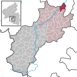
Odenbach
| Odenbach | ||
|---|---|---|
|
||
| Coordinates: 49°41′05″N 7°39′05″E / 49.68472°N 7.65139°ECoordinates: 49°41′05″N 7°39′05″E / 49.68472°N 7.65139°E | ||
| Country | Germany | |
| State | Rhineland-Palatinate | |
| District | Kusel | |
| Municipal assoc. | Lauterecken-Wolfstein | |
| Government | ||
| • Mayor | Gerhard Gins | |
| Area | ||
| • Total | 7.95 km2 (3.07 sq mi) | |
| Elevation | 160 m (520 ft) | |
| Population (2015-12-31) | ||
| • Total | 841 | |
| • Density | 110/km2 (270/sq mi) | |
| Time zone | CET/CEST (UTC+1/+2) | |
| Postal codes | 67748 | |
| Dialling codes | 06753 | |
| Vehicle registration | KUS | |
| Website | vg-lauterecken.de | |
Odenbach is an Ortsgemeinde – a municipality belonging to a Verbandsgemeinde, a kind of collective municipality – in the Kusel district in Rhineland-Palatinate, Germany. It belongs to the Verbandsgemeinde Lauterecken-Wolfstein.
The municipality lies northeast of Lauterecken at the mouth of the namesake river Odenbach, where it empties into the river Glan in the North Palatine Uplands. Odenbach also lies on Bundesstraße 420. The village lies on both sides of the Glan where the valley floor’s elevation is 155 m above sea level. The valleys are squeezed somewhat into a narrow gap by various mountains. Foremost of these on the Glan’s left bank are the Bennerberg (308 m) and the Bornberg with its outliers stretching towards Meisenheim, while on the right bank are the Galgenberg (326 m above sea level) and the Hagelkreuz (357 m). Furthermore, in the gore formed by the Glan and Odenbach is the plateau of the Hellerwald and the Streit. The municipal area measures 800 ha, of which 465 ha is farmed, 233 ha is wooded (municipality’s share, 54 ha), 83 ha is settled or used for transport, 8 ha is recreational and 11 ha is open water.
Odenbach borders in the north on the town of Meisenheim, in the east on the municipalities of Reiffelbach and Becherbach, in the south on the municipality of Adenbach, in the southwest on the municipality of Cronenberg and in the west on the municipality of Medard.
...
Wikipedia


