Ohio River Valley
| Ohio River |
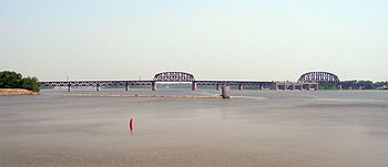
The widest point on the Ohio River is just west of downtown Louisville, where it is one mile (1.6 km) wide |
| Country |
United States |
| States |
Pennsylvania, Ohio, West Virginia, Kentucky, Indiana, Illinois
|
|
| Tributaries |
| - left |
Little Kanawha River, Kanawha River, Little Sandy River, Big Sandy River, Licking River, Kentucky River, Green River, Cumberland River, Tennessee River
|
| - right |
Beaver River, Little Muskingum River, Muskingum River, Little Hocking River, Hocking River, Shade River, Scioto River, Little Miami River, Great Miami River, Wabash River
|
| Cities |
Pittsburgh, PA, Wheeling, WV, Huntington, WV, Parkersburg, WV, Cincinnati, OH, Louisville, KY, Owensboro, KY, Evansville, IN, Henderson, KY, Paducah, KY, Cairo, IL
|
|
|
| Source |
Allegheny River |
| - location |
Allegany Township, Potter County, Pennsylvania
|
| - elevation |
2,240 ft (683 m) |
| - coordinates |
41°52′22″N 77°52′30″W / 41.87278°N 77.87500°W / 41.87278; -77.87500 |
| Secondary source |
Monongahela River |
| - location |
Fairmont, West Virginia
|
| - elevation |
880 ft (268 m) |
| - coordinates |
39°27′53″N 80°09′13″W / 39.46472°N 80.15361°W / 39.46472; -80.15361 |
| Source confluence |
|
| - location |
Pittsburgh, Pennsylvania
|
| - elevation |
730 ft (223 m) |
| - coordinates |
40°26′32″N 80°00′52″W / 40.44222°N 80.01444°W / 40.44222; -80.01444 |
| Mouth |
Mississippi River |
| - location |
Cairo, Illinois / Ballard County, Kentucky
|
| - elevation |
290 ft (88 m) |
| - coordinates |
36°59′12″N 89°07′50″W / 36.98667°N 89.13056°W / 36.98667; -89.13056Coordinates: 36°59′12″N 89°07′50″W / 36.98667°N 89.13056°W / 36.98667; -89.13056 |
|
| Length |
981 mi (1,579 km) |
| Basin |
189,422 sq mi (490,601 km2) |
| Discharge |
for Cairo, Illinois
|
| - average |
281,000 cu ft/s (7,957 m3/s) (1951–80)
|
| - max |
1,850,000 cu ft/s (52,386 m3/s) |
|
|
Ohio River basin
|
The Ohio River, which streams westward from Pittsburgh, Pennsylvania, to Cairo, Illinois, is the largest tributary, by volume, of the Mississippi River in the United States. At the confluence, the Ohio is considerably bigger than the Mississippi (Ohio at Cairo: 281,500 cu ft/s (7,960 m3/s); Mississippi at Thebes: 208,200 cu ft/s (5,897 m3/s)) and, thus, is hydrologically the main stream of the whole river system, including the Allegheny River further upstream.
The 981-mile (1,579 km) river flows through or along the border of six states, and its drainage basin includes parts of 15 states. Through its largest tributary, the Tennessee River, the basin includes many of the states of the southeastern U.S. It is the source of drinking water for three million people.
It is named in Iroquoian or Seneca: Ohi:yó, lit. "Good River" or Shawnee: Pelewathiipi and Spelewathiipi. The river had great significance in the history of the Native Americans, as numerous civilizations formed along its valley. For thousands of years, Native Americans used the river as a major transportation and trading route. Its waters connected communities. In the five centuries before European conquest, the Mississippian culture built numerous regional chiefdoms and major earthwork mounds in the Ohio Valley, such as Angel Mounds near Evansville, Indiana, as well as in the Mississippi Valley and the Southeast. The Osage, Omaha, Ponca and Kaw lived in the Ohio Valley, but under pressure from the Iroquois to the northeast, migrated west of the Mississippi River to Missouri, Arkansas and Oklahoma in the 17th century.
...
Wikipedia


