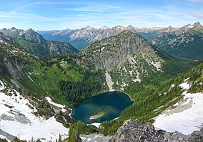
Okanogan National Forest
| Okanogan National Forest | |
|---|---|
|
IUCN category VI (protected area with sustainable use of natural resources)
|
|

Okanogan Valley from Maple Pass
|
|
|
Location in the United States
|
|
| Location | Okanogan County, Washington |
| Nearest city | Omak, WA |
| Coordinates | 48°33′06″N 120°23′06″W / 48.5517°N 120.385°WCoordinates: 48°33′06″N 120°23′06″W / 48.5517°N 120.385°W |
| Area | 1,499,023 acres (6,066.33 km2) |
| Established | July 1, 1911 |
| Visitors | 397,000 (in 2005) |
| Governing body | United States Forest Service |
| Okanogan-Wenatchee National Forest | |
The Okanogan National Forest is a U.S. National Forest located in Okanogan County in north-central Washington, United States.
The 1,499,013-acre (2,342.208 sq mi; 6,066.29 km2) forest is bordered on the north by British Columbia, on the east by Colville National Forest, on the south by the divide between the Methow and the Stehekin–Lake Chelan valleys, and on the west by North Cascades National Park. The closest significant communities are Omak and Okanogan. Managed by the United States Forest Service together with Wenatchee National Forest, its headquarters are in Wenatchee. There are local ranger district offices located in Tonasket and Winthrop. It is the second-largest national forest (after the Nez Perce National Forest in Idaho) that is contained entirely within one county and largest of which in Washington.
Most of the Pasayten Wilderness (excluding its westernmost part, which lies in the Mount Baker-Snoqualmie National Forest), and the northeast portion (about 63%) of Lake Chelan-Sawtooth Wilderness are part of the forest, with the balance lying in the Mount Baker-Snoqualmie National Forest.
...
Wikipedia

