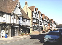
Old Oxted
| Oxted | |
|---|---|
 The timber-framed stucco façades of buildings in Oxted |
|
|
Oxted shown within Surrey
|
|
| Area | 15.15 km2 (5.85 sq mi) |
| Population | 11,314 (Civil Parish 2011) |
| • Density | 747/km2 (1,930/sq mi) |
| OS grid reference | TQ3953 |
| • London | 17.9 mi (28.8 km) |
| Civil parish |
|
| District | |
| Shire county | |
| Region | |
| Country | England |
| Sovereign state | United Kingdom |
| Post town | OXTED |
| Postcode district | RH8 |
| Dialling code | 01883 |
| Police | Surrey |
| Fire | Surrey |
| Ambulance | South East Coast |
| EU Parliament | South East England |
| UK Parliament | |
Oxted is a town and civil parish in the Tandridge district of Surrey, England, at the foot of the North Downs. The town is located around 9 miles (14 km) south-east of Croydon in Greater London, 8.5 miles (13.7 km) west of Sevenoaks in Kent, and 9 miles (14 km) north of East Grinstead in West Sussex.
Oxted is a commuter town with a railway station, with direct train services to London. Its main developed area is contiguous with the village of Limpsfield. The source of the River Eden, a tributary of the River Medway, is just north at Titsey.
The settlements of Hurst Green and Holland are also within the civil parish.
The town lay within the Anglo-Saxon Tandridge hundred. Oxted appears in the Domesday Book of 1086 as Acstede, meaning 'Place where oaks grew'. It was held by Eustace II of Boulogne. Its Domesday assets were: 5 hides; 1 church, 2 mills worth 12s 6d, 20 ploughs, 4 acres (1.6 ha) of meadow, pannage worth 100 hogs. It rendered £14 and 2d from a house in Southwark to its feudal overlords per year.
...
Wikipedia

