One Fathom Bank

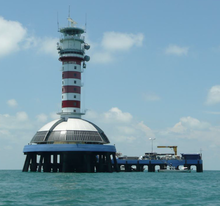
The "new" One Fathom Bank Lighthouse, activated 1999.
|
|
| Location | One Fathom Bank (Permatang Sedepa), off the coast of Selangor, Malaysia |
|---|---|
| Coordinates | 2°53′03″N 100°59′08″E / 2.88417°N 100.98556°ECoordinates: 2°53′03″N 100°59′08″E / 2.88417°N 100.98556°E |
| Year first constructed | 1852 (first) 1874 (second) 1907 (third) |
| Year first lit | 1999 (current) |
| Deactivated | 1999 (third) |
| Construction | pile lighthouse (current and third) |
| Tower shape | cylindrical tower with triple balcony and lantern(current) octagonal tower (third) |
| Markings / pattern | red and white horizontal bands tower (third and current) |
| Height | 27 metres (89 ft) (third); 43 metres (141 ft) (current) |
| Focal height | 43 metres (141 ft) |
| Range | 23 nautical miles (43 km; 26 mi) |
| Characteristic | Fl (4) W 20s. |
| Admiralty number | F1616 (current) |
| NGA number | 21784 (current) |
| ARLHS number |
WMA-030 (third); WMA-007 (current) |
|
[]
|
|
The One Fathom Bank Lighthouse (Malay: Rumah Api One Fathom Bank or Rumah Api Permatang Sedepa) refers to two offshore lighthouses in the Strait of Malacca, specifically, on a shoal within Malaysian waters, dubbed One Fathom Bank (Permatang Sedepa), off the coast of the state of Selangor.
The One Fathom Bank station originally consisted of a single screw-pile lighthouse that has been replaced twice over the course of its 147 years in service, but saw the addition of a newer, larger counterpart close by that superseded duties of the older lighthouse in 1999. The lighthouses have since been referred to as the "old" One Fathom Bank Lighthouse and the "new" One Fathom Bank Lighthouse; the old One Fathom Bank Lighthouse is retained but is currently inactive.
As neither lighthouse is located on any body of dry land, both locations are only accessible by boat. While both sites of the lighthouses are open, their towers remain off-limits.
First reported during the mid-19th century by John Turnbull Thomson, a hydrographic surveyor, One Fathom Bank is a shoal located in the Strait of Malacca, between North Sands and South Sands, 30 kilometres (19 mi) southwest from the Klang Delta in Selangor. The sandbank had apparently emerged during low tide, with water depths of less than two and a half fathoms (4.6 m).
The first move by the Government of India in Bengal in 1848 was to send two buoys to be placed to warn mariners. It was agreed that one should be placed on One Fathom Bank (at the time always called 2 and 1/2 Fathom Bank), but no one could agree what the second should mark, opinions varying from Blenheim Shoal through South Sands to as far south as Pyramid Shoal. In any case, most contemporary arguments favoured a lightship, since unlit buoys offered no aid to navigation at night. By 1850 arguments in favour of a screw pile structure were being advanced, reference being made to the recent British example at Maplin Sands. However, it seems that possible doubts about the solidity of One Fathom Bank led to the British placing a lightship at the site in 1852. Called the Torch, the vessel had previously been stationed of Sagar Point at the mouth of the Hooghly River. That there may have been uncertainty is reflected in the debate about what should be the next light towards Singapore that appeared in the Singapore newspapers during the late 1850s. A government reply declared that the placement of a screw pile structure on Pyramid Shoal was to be refused on the grounds of the unsuitability of the seabed for such a structure. Nonetheless, if doubts there had been, by the early 1870s they had been stilled and the lightship, in increasingly poor repair, was replaced by a screw-pile lighthouse in 1874. This was followed by a second, concrete pile lighthouse in 1907, completed at the cost of £246,963.31, which remains standing to date.
...
Wikipedia

