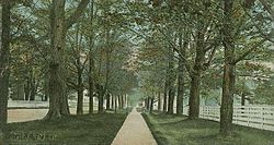
Orford, NH
| Orford, New Hampshire | |
|---|---|
| Town | |

The Mall c. 1906
|
|
 Location in Grafton County, New Hampshire |
|
| Coordinates: 43°54′18″N 72°08′15″W / 43.90500°N 72.13750°WCoordinates: 43°54′18″N 72°08′15″W / 43.90500°N 72.13750°W | |
| Country | United States |
| State | New Hampshire |
| County | Grafton |
| Incorporated | 1761 |
| Government | |
| • Board of Selectmen | John Adams, Chair Paul J. Goundrey David Smith |
| Area | |
| • Total | 48.0 sq mi (124.4 km2) |
| • Land | 46.7 sq mi (120.9 km2) |
| • Water | 1.4 sq mi (3.5 km2) 2.81% |
| Elevation | 407 ft (124 m) |
| Population (2010) | |
| • Total | 1,237 |
| • Density | 26/sq mi (9.9/km2) |
| Time zone | Eastern (UTC-5) |
| • Summer (DST) | Eastern (UTC-4) |
| ZIP code | 03777 |
| Area code(s) | 603 |
| FIPS code | 33-58500 |
| GNIS feature ID | 0873693 |
| Website | www |
Orford is a town in Grafton County, New Hampshire, United States. The population was 1,237 at the 2010 census. The Appalachian Trail crosses in the east.
First called Number Seven in a line of Connecticut River fort towns, Orford was incorporated in 1761 by Governor Benning Wentworth and named for Robert Walpole, Earl of Orford, who was England's first prime minister. It was settled in 1765 by Daniel Cross and wife from Lebanon, Connecticut. By 1859, it had 1,406 inhabitants, most involved in agriculture. There was a large tannery, chair factory, 10 sawmills, a starch factory, a gristmill, a sash, blind and door factory, and 2 boot and shoe factories.
An original grantee was General Israel Morey, whose son Samuel Morey discovered a way to separate hydrogen from oxygen in water, making possible the first marine steam engine. He recognized the potential of steam power after working at his father's ferry. In 1793, on the river at Orford, he was first to demonstrate the use of a paddlewheel to propel a steam boat.
...
Wikipedia
