Outwell
| Outwell | |
|---|---|
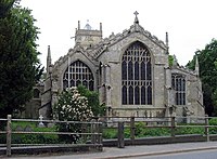
 Saint Clements, Outwell, Norfolk |
|
| Outwell shown within Norfolk | |
| Area | 12.21 km2 (4.71 sq mi) |
| Population | 2,083 (parish, 2011 census) |
| • Density | 171/km2 (440/sq mi) |
| OS grid reference | TF5103 |
| • London | 97 miles (156 km) |
| Civil parish |
|
| District | |
| Shire county | |
| Region | |
| Country | England |
| Sovereign state | United Kingdom |
| Post town | WISBECH |
| Postcode district | PE14 |
| Dialling code | 01945 |
| Police | Norfolk |
| Fire | Norfolk |
| Ambulance | East of England |
| EU Parliament | East of England |
| UK Parliament | |
Outwell is a village and a civil parish in the English county of Norfolk The village is 53.4 miles (85.9 km) west of Norwich, 18.3 miles (29.5 km) south-west of King's Lynn and 97 miles (156 km) north of London. The nearest town is Wisbech which is 5.1 miles (8.2 km) north west of the village. The Village is on the route of the A1101Bury St. Edmunds to Long Sutton road. The nearest railway station is at Downham Market for the Fen Line which runs between King's Lynn and Cambridge. The nearest airport is Norwich International Airport. The parish of Outwell in the 2001 census, has a population of 1,880, increasing to 2,083 at the 2011 Census. For the purposes of local government, the parish falls within the district of King's Lynn and West Norfolk.
The village and parish of Outwell is located on the western edge of the county of Norfolk which borders Cambridgeshire. Up until 1990 Outwell parish was split with half in Norfolk and half in Cambridgeshire with the boundary falling along the old course of the River Nene. The boundary also cut straight through the middle of the village. In 1935 the part of Outwell which was in Cambridgeshire was reduced in size to enlarge the nearby village of Emneth. Outwell parish today is part of the King's Lynn and West Norfolk local government district.
...
Wikipedia

