Oyo State, Nigeria
| Ọyọ State | |
|---|---|
| State | |
| Nickname(s): Pace Setter State | |
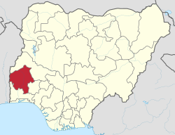
 Location of Ọyọ State in Nigeria |
|
| Coordinates: 8°00′N 4°00′E / 8.000°N 4.000°ECoordinates: 8°00′N 4°00′E / 8.000°N 4.000°E | |
| Country |
|
| Established | late 14th century |
| Date created | 3 February 1976 |
| Capital | Ibadan |
| Government | |
| • Governor | Abiola Ajimobi (APC) |
| • Representatives | List |
| Area | |
| • Total | 28,454 km2 (10,986 sq mi) |
| Population (2006) | |
| • Total | 5,591,589 |
| • Estimate (2007) | 6,617,720 |
| • Density | 200/km2 (510/sq mi) |
| GDP | |
| • Year | 2007 |
| • Total | $16,12 billion |
| • Per capita | $2,666 |
| Time zone | WAT (UTC+01) |
| ISO 3166 code | NG-OY |
| Website | oyostate.gov.ng |
Ọyọ, usually referred to as Oyo State to distinguish it from the city of Oyo, is an inland state in south-western Nigeria, with its capital at Ibadan. It is bounded in the north by Kwara State, in the east by Osun State, in the south by Ogun State and in the west partly by Ogun State and partly by the Republic of Benin.
Oyo State covers approximately an area of 28,454 square kilometers and is ranked 14th by size. The landscape consists of old hard rocks and dome shaped hills, which rise gently from about 500 meters in the southern part and reaching a height of about 1,219 metre above sea level in the northern part. Some principal rivers such as Ogun, Oba, Oyan, Otin, Ofiki, Sasa, Oni, Erinle and Osun river originate in this highland.
Oyo State contain a number of natural features including the Old Oyo National Park. In this location there was earlier habitat for the endangered African wild dog, Lycaon pictus; however, this canid is thought to have been locally extirpated at the present.
The Climate is equatorial, notably with dry and wet seasons with relatively high humidity. The dry season lasts from November to March while the wet season starts from April and ends in October. Average daily temperature ranges between 25 °C (77.0 °F) and 35 °C (95.0 °F), almost throughout the year.
...
Wikipedia
