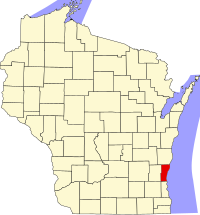
Ozaukee County
| Ozaukee County, Wisconsin | |
|---|---|

Ozaukee County Courthouse in July 2009
|
|
 Location in the U.S. state of Wisconsin |
|
 Wisconsin's location in the U.S. |
|
| Founded | 1853 |
| Seat | Port Washington |
| Largest city | Mequon |
| Area | |
| • Total | 1,116 sq mi (2,890 km2) |
| • Land | 233 sq mi (603 km2) |
| • Water | 883 sq mi (2,287 km2), 79% |
| Population | |
| • (2010) | 86,395 |
| • Density | 371/sq mi (143/km²) |
| Congressional district | 6th |
| Time zone | Central: UTC-6/-5 |
| Website | www |
Ozaukee County is a county in the U.S. state of Wisconsin. As of the 2010 census, the population was 86,395. Its county seat is Port Washington.
Ozaukee County is included in the Milwaukee-Waukesha-West Allis, WI Metropolitan Statistical Area.
As of the 2000 Census, Ozaukee County had the 2nd lowest poverty rate of any county in the United States, at 2.6%. In terms of per capita income, it is the 25th wealthiest county in the country. Bolstered by low crime rates and school districts with high graduation rates, Forbes magazine ranked Ozaukee County #2 on its list of "America's Best Places To Raise A Family" in June, 2008.
Ozaukee County was once part of neighboring Washington County to the west. Its name comes from the Ojibwe name for the Sacs. The word probably means "people living at the mouth of a river."
According to the U.S. Census Bureau, the county has a total area of 1,116 square miles (2,890 km2), of which 233 square miles (600 km2) is land and 883 square miles (2,290 km2) (79%) is water. It is the second-smallest county in Wisconsin by land area.
Lion's Den Gorge Nature Preserve is a large bluffland and wetland county protected area on the shore of Lake Michigan.
As of the census of 2000, there were 82,317 people, 30,857 households, and 23,019 families residing in the county. The population density was 355 people per square mile (137/km²). There were 32,034 housing units at an average density of 138 per square mile (53/km²). The racial makeup of the county was 96.72% White, 0.93% Black or African American, 0.20% Native American, 1.07% Asian, 0.02% Pacific Islander, 0.34% from other races, and 0.73% from two or more races. 1.30% of the population were Hispanic or Latino of any race. 47.2% were of German, 7.3% Irish and 6.7% Polish ancestry according to Census 2000. 95.1% spoke English, 1.6% Spanish and 1.4% German as their first language.
...
Wikipedia
