Parc Natural de Sant Llorenç del Munt i l'Obac
| Sant Llorenç del Munt | |
|---|---|

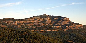
La Mola with the monastery on top
|
|
| Highest point | |
| Elevation | 1,104 m (3,622 ft) |
| Coordinates | 41°38′29″N 02°01′05″E / 41.64139°N 2.01806°ECoordinates: 41°38′29″N 02°01′05″E / 41.64139°N 2.01806°E |
| Geography | |
| Location |
Bages, Vallès Occidental, Catalonia |
| Parent range | Catalan Pre-Coastal Range |
| Geology | |
| Mountain type | Conglomerate |
| Climbing | |
| First ascent | Unknown |
| Easiest route | Camí dels Monjos from Sant Cugat del Vallès |
Sant Llorenç del Munt is a largely rocky mountain massif in central Catalonia, Spain. The highest summit, where the Monestir de Sant Llorenç del Munt is located, has an elevation of 1,104.2 metres (3,623 ft) above sea level and is known as La Mola.Montcau 1,056.8 metres (3,467 ft) is another important peak of the massif. On the massif, there is a protected area under the name Parc Natural de Sant Llorenç del Munt i l'Obac.
...
Wikipedia
