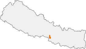
Parsa Wildlife Reserve
| Parsa National Park | |
|---|---|
|
IUCN category II (national park)
|
|

Location in Nepal
|
|
| Location | Nepal |
| Nearest city | Birgunj |
| Coordinates | 27°28′N 84°20′E / 27.467°N 84.333°ECoordinates: 27°28′N 84°20′E / 27.467°N 84.333°E |
| Area | 637.37 km2 (246.09 sq mi) |
| Established | 1984 |
| Governing body | Department of National Parks and Wildlife Conservation, Ministry of Forests and Soil Conservation |
Parsa National Park is a protected area in the Inner Terai lowlands of south-central Nepal. Established in 1984 A.D, it covers an area of 637.37 km2 (246.09 sq mi) in the Parsa, Makwanpur and Bara districts and is the largest wildlife reserve in the country. A bufferzone declared in 2005 comprises 298.2 km2 (115.1 sq mi). In altitude it ranges from 435 m (1,427 ft) to 950 m (3,120 ft) in the Siwalik Hills. In 2015, the protected area has been extended by 128 km2 (49 sq mi).
In the north of the protected area the Rapti River and Siwalik Hills form a natural boundary to human settlements. In the east it extends up to the Hetauda – Birgunj highway. In the south, a forest roads demarcates the boundary. Adjacent to the west is Chitawan National Park. Together with the Indian Tiger Reserve Valmiki National Park, the coherent protected area of 2,075 km2 (801 sq mi) represents the Tiger Conservation Unit (TCU) Chitwan-Parsa-Valmiki, which covers a 3,549 km2 (1,370 sq mi) block of alluvial grasslands and subtropical moist deciduous forests.
Before being converted to a protected area, the region used to be a hunting ground of the ruling class.
The typical vegetation of the park is tropical and subtropical forest types with sal forest constituting about 90% of the vegetation. Chir pine grows in the Churia Hills. Khair, sissoo and silk cotton trees occur along watercourses. Sabai grass grows well on the southern face of the Churia Hills.
...
Wikipedia
