Pemiscot County
| Pemiscot County, Missouri | |
|---|---|

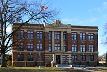
Pemiscot County Courthouse in Caruthersville
|
|
 Location in the U.S. state of Missouri |
|
 Missouri's location in the U.S. |
|
| Founded | February 19, 1851 |
| Named for | A Native American word meaning "liquid mud" |
| Seat | Caruthersville |
| Largest city | Caruthersville |
| Area | |
| • Total | 513 sq mi (1,329 km2) |
| • Land | 493 sq mi (1,277 km2) |
| • Water | 21 sq mi (54 km2), 4.1% |
| Population (est.) | |
| • (2015) | 17,482 |
| • Density | 37/sq mi (14/km²) |
| Congressional district | 8th |
| Time zone | Central: UTC-6/-5 |
| Pemiscot County, Missouri | ||||
|---|---|---|---|---|
| Elected countywide officials | ||||
| Assessor | Patsy Hinklin | Democratic | ||
| Circuit Clerk | Kelly Cagle Maners | Democratic | ||
| County Clerk | Pam Treece | Democratic | ||
| Collector | Rhonda Parkinson Price | Democratic | ||
|
Commissioner (Presiding) |
Mark Cartee | Democratic | ||
|
Commissioner (District 1) |
Steve Watkins | Democratic | ||
|
Commissioner (District 2) |
Ben Baker | Democratic | ||
| Coroner | James Brimhall | Democratic | ||
| Emergency Management Director | Jim Atchison | Democratic | ||
| Prosecuting Attorney | Jereme Lytle | Democratic | ||
| Public Administrator | Carol DeRousse Miller | Democratic | ||
| Recorder | Pam Strawbridge | Democratic | ||
| Sheriff | Tommy Greenwell | Democratic | ||
| Surveyor | Darrall Hirtz | Democratic | ||
| Treasurer | Frankie R. Stewart | Democratic | ||
| Pemiscot County, Missouri | |
|---|---|
| 2008 Republican primary in Missouri | |
| John McCain | 233 (23.75%) |
| Mike Huckabee | 565 (57.59%) |
| Mitt Romney | 149 (15.19%) |
| Ron Paul | 20 (2.04%) |
| Pemiscot County, Missouri | |
|---|---|
| 2008 Democratic primary in Missouri | |
| Hillary Clinton | 1,270 (70.83%) |
| Barack Obama | 466 (25.99%) |
| John Edwards (withdrawn) | 34 (1.90%) |
| Uncommitted | 19 (1.06%) |
Pemiscot County is a county located in the southeastern corner in the Bootheel in the U.S. state of Missouri. As of the 2010 census, the population was 18,296. The largest city and county seat is Caruthersville. The county was officially organized on February 19, 1851, and is named for the local bayou, taken from the Fox dialect word, pem-eskaw, meaning "liquid mud". Bordering the Mississippi River and floodplain, the county has been devoted to agricultural development and commodity crops. With mechanization of agriculture, its population has declined since a peak in 1940.
Murphy Mound Archeological Site has one of the largest platform mounds in Missouri; it is a major earthwork of the Late Mississippian culture, which had settlement sites throughout the Mississippi Valley and tributaries. The site is privately owned and is not open to the public. The site may have been occupied from as early as 1200 CE and continuing to about 1541.
According to the U.S. Census Bureau, the county has a total area of 513 square miles (1,330 km2), of which 493 square miles (1,280 km2) is land and 21 square miles (54 km2) (4.1%) is water. Fishing is a popular activity among residents in the area.
As of the census of 2000, there were 20,047 people, 7,855 households, and 5,317 families residing in the county. The population density was 41 people per square mile (16/km²). There were 8,793 housing units at an average density of 18 per square mile (7/km²). The racial makeup of the county was 71.76% White, 26.23% Black or African American, 0.25% Native American, 0.27% Asian, 0.01% Pacific Islander, 0.62% from other races, and 0.85% from two or more races. Approximately 1.57% of the population were Hispanic or Latino of any race. Among the major first ancestries reported in Pemiscot County were 31.9% American, 7.8% Irish, 5.6% English, and 5.5% German ancestry.
...
Wikipedia
