Pennsylvania Avenue (Washington, D.C.)

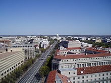
Looking southeast down Pennsylvania Avenue, NW towards the United States Capitol seen here from the Old Post Office Pavilion.
|
|
| Length | 35.1 mi (56.5 km) |
|---|---|
| Location |
Washington, D.C. Prince George's County, Maryland |
| Coordinates | 38°53′37″N 77°01′26″W / 38.893738°N 77.023901°W |
Pennsylvania Avenue is a street in Washington, D.C. that connects the White House and the United States Capitol. Called "America's Main Street", it is the location of official parades and processions, as well as protest marches. Moreover, Pennsylvania Avenue is an important commuter route and is part of the National Highway System.
The avenue runs for a total of 5.8 miles (9.3 km) inside Washington, but the 1.2 miles (1.9 km) of Pennsylvania Avenue from the White House to the United States Capitol building is considered the most important. It continues within the city for 3.5 miles (5.6 km), from the southeast corner of the Capitol grounds through the Capitol Hill neighborhood, and over the Anacostia River on the John Philip Sousa Bridge. Crossing the entire width of Prince George's County, Maryland, it ends 14.5 miles (23.3 km) from the DC line at its junction with MD Route 408 at Waysons Corner near the Patuxent River, for a total length of 20.3 miles (32.7 km). At this point, as a limited-access highway, it becomes Southern Maryland Boulevard. On October 20, 2012, Maryland Governor Martin O'Malley issued a proclamation which named the part of Pennsylvania Avenue east of Water Street in Upper Marlboro and just north of her home town of Croom, Maryland the Stephanie Roper Highway In addition to its street names, in Maryland it is designated as Maryland Route 4. At one point in the mid-20th century, Pennsylvania Avenue was designated DC 4, an extension of Maryland Route 4 that reached at least the east side of the White House.
...
Wikipedia
