Piketon, Ohio
| Piketon, Ohio | |
|---|---|
| Village | |
 Location of Piketon, Ohio |
|
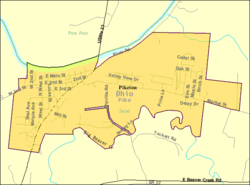
 Detailed map of Piketon |
|
| Coordinates: 39°4′4″N 83°0′33″W / 39.06778°N 83.00917°WCoordinates: 39°4′4″N 83°0′33″W / 39.06778°N 83.00917°W | |
| Country | United States |
| State | Ohio |
| County | Pike |
| Area | |
| • Total | 2.55 sq mi (6.60 km2) |
| • Land | 2.50 sq mi (6.47 km2) |
| • Water | 0.05 sq mi (0.13 km2) |
| Elevation | 574 ft (175 m) |
| Population (2010) | |
| • Total | 2,181 |
| • Estimate (2012) | 2,158 |
| • Density | 872.4/sq mi (336.8/km2) |
| Time zone | Eastern (EST) (UTC-5) |
| • Summer (DST) | EDT (UTC-4) |
| ZIP code | 45661 |
| Area code(s) | 740 |
| FIPS code | 39-62708 |
| GNIS feature ID | 1061541 |
Piketon is a village in Pike County, Ohio, United States, along the Scioto River. The village is best known for the uranium enrichment plant located there (one of only three such plants in the United States). The population was 2,181 at the 2010 census. Originally called Jefferson, it was the county seat of Pike County 1815–1845, when it was decided by James Emmitt, a wealthy local entrepreneur, to move the county seat to Waverly due to its closer proximity to the then new Ohio & Erie Canal. Piketon is the location of the Pike County Fairgrounds and is served by the Scioto Valley School District.
Perhaps the best-known historic resident of Piketon was Robert Lucas, the governor of Ohio and territorial governor of Iowa. Around 1824, Lucas built a large brick house two miles east of Piketon, named Friendly Grove, which became a center of local political activity.
Piketon is served by the Western and Piketon branches of the Garnet A. Wilson Public Library.
Piketon corporation limit sign.
Looking east on Main Street in Piketon.
Water tower in Piketon, Ohio.
Old Court House, completed in 1819.
Piketon is located at 39°4′4″N 83°0′33″W / 39.06778°N 83.00917°W (39.067801, -83.009207).
According to the United States Census Bureau, the village has a total area of 2.55 square miles (6.60 km2), of which 2.50 square miles (6.47 km2) is land and 0.05 square miles (0.13 km2) is water.
...
Wikipedia
