Pila, Laguna
| Pila | ||
|---|---|---|
| Municipality | ||

Aerial view of Pila with Sta Cruz in background
|
||
|
||
| Nickname(s): La Noble Villa de Pila | ||
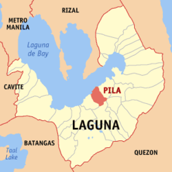
 Map of Laguna showing the location of Pila |
||
| Location within the Philippines | ||
| Coordinates: 14°14′N 121°22′E / 14.233°N 121.367°ECoordinates: 14°14′N 121°22′E / 14.233°N 121.367°E | ||
| Country | Philippines | |
| Region | Calabarzon (Region IV-A) | |
| Province | Laguna | |
| District | 4th district of Laguna | |
| Founded | July 29, 1575 | |
| Barangays | 17 | |
| Area | ||
| • Total | 31.20 km2 (12.05 sq mi) | |
| Population (2010) | ||
| • Total | 46,534 | |
| • Density | 1,500/km2 (3,900/sq mi) | |
| Time zone | PST (UTC+8) | |
| ZIP code | 4010 | |
| IDD : area code | +63 (0)49 | |
| Income class | 3rd | |
Pila is a third class municipality in the province of Laguna, Philippines. According to the 2010 census, it has a population of 46,534 people. Pila has a total land area of 31.2 km².
The town of Pila is the site for some well-preserved houses dating back to the Spanish period as well as the old Saint Anthony of Padua Parish Church, the first Antonine church in the Philippines.
Don Felizardo Rivera, who donated his lands to the church and municipal government, is the recognized founder of Pila. He is the ancestor of prominent families in Pila surnamed Rivera, Relova, Agra and Álava.
This also served as a location for the reality show, The Amazing Race Asia 2 and the ABS-CBN daytime drama hit series Be Careful With My Heart.
Pila is politically subdivided into 17 barangays. In 1957, the sitio of Pinagbayanan was converted into a barrio.
Pila and adjacent towns along the shores of Laguna de Bay are considered by archaeologists as one of the oldest settlements in the Philippines. The community is one of three such concentrations of population known archaeologically to have been in place before A.D. 1000. Archaeologists recovered in Pinagbayanan potteries and artifacts that indicate considerable settlement in the area during the Late Tang Dynasty (900 A.D.). Archaeologists also recovered ancient horse bones ending the debate on whether the Spaniards brought them or not. The scientists were able to uncover Philippines’ oldest crematorium in the same area. It is worthwhile to note that the oldest Philippine document, the 900 A.D. Laguna Copperplate Inscription, mentioned Pila (as Pailah) twice and its ruler Jayadewa.
Pre-Hispanic Pila was one of the biggest barangay domains in Southern Luzon. Its leader was not only the local chief but also the regional datu. The bards of the shore towns of the Morong Peninsula across the lake from Pila sang of the exploits of Gat Salyan Maguinto, the “gold-rich” datu of Pila who extended his kingdom far and wide into their settlements. In fact, the greater territory was also called Pila. Wary of concentrating power on a noble Indio, the conquistadors later dismantled his realm and to avoid confusion, they changed the name of the Pila dependencies to Pililla, which means “minor Pila.” The original territory had encompassed the present towns of Morong (from which the town of Pililla or Pilang Morong separated in 1583); Baras (separated from Morong in 1588); Tanay (separated from Pililla in 1606); Jala-jala whose old name was also Pila (separated from Pililla in 1786) and Talim Island, which until now, has a sitio Pila. The descendants of Gat Salyan were also regarded as the founders of the other towns of the present province of Rizal.
...
Wikipedia


