Plitvice Lakes National Park
| Plitvice Lakes National Park | |
|---|---|
| Croatian: Nacionalni park Plitvička jezera | |

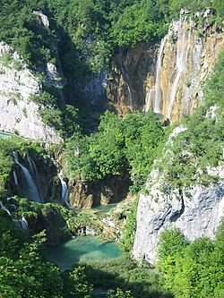
The large waterfall
|
|
| Location | Lika-Senj County, Karlovac County, Croatia |
| Coordinates | 44°52′50″N 15°36′58″E / 44.88056°N 15.61611°ECoordinates: 44°52′50″N 15°36′58″E / 44.88056°N 15.61611°E |
| Area | 296.85 km2 |
| Elevation | 367 m (Korana bridge), 1279 m (Seliški vrh) |
| Visitors | 1,367,304 (in 2015) |
| Governing body | Javna ustanova Nacionalni park Plitvička jezera HR-53231 Plitvička jezera Tel. +385 (0)53 751 015 www.np-plitvicka-jezera.hr |
| Type | Natural |
| Criteria | vii, viii, ix |
| Designated | 1979 (3rd Session) |
| Reference no. | 98 |
| Europe and North America | |
| Extensions | 2000 |
| Endangered | 1992–1997 |
|
IUCN Category II (National Park)
|
|
| Type | Natural |
| Designated | 1979 |
| State Party | Croatia |
| Official name: Nacionalni park Plitvička jezera | |
| Designated | April 8, 1949 |
Plitvice Lakes National Park (Croatian: Nacionalni park Plitvička jezera, colloquial Plitvice, pronounced [plîtʋitse]) is one of the oldest national parks in Southeast Europe and the largest national park in Croatia. In 1979, Plitvice Lakes National Park was added to the UNESCO World Heritage register.
The national park was founded in 1949 and is situated in the mountainous karst area of central Croatia, at the border to Bosnia and Herzegovina. The important north-south road connection, which passes through the national park area, connects the Croatian inland with the Adriatic coastal region.
The protected area extends over 296.85 square kilometres (73,350 acres). About 90% of this area is part of Lika-Senj County, while the remaining 10% is part of Karlovac County.
Each year, more than 1 million visitors are recorded. Entrance is subject to variable charges, up to 180 kuna or around €24 per adult in peak season.
The national park is world-famous for its lakes arranged in cascades. Currently, 16 lakes can be seen from the surface. These lakes are a result of the confluence of several small rivers and subterranean karst rivers. The lakes are all interconnected and follow the water flow. They are separated by natural dams of travertine, which is deposited by the action of moss, algae, and bacteria. The particularly sensitive travertine barriers are the result of an interplay between water, air and plants. The encrusted plants and bacteria accumulate on top of each other, forming travertine barriers which grow at the rate of about 1 cm (0.4 in) per year.
...
Wikipedia

