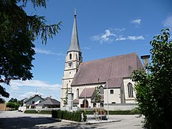
Polling im Innkreis
| Polling im Innkreis | ||
|---|---|---|
 |
||
|
||
| Location within Austria | ||
| Coordinates: 48°13′50″N 13°16′50″E / 48.23056°N 13.28056°ECoordinates: 48°13′50″N 13°16′50″E / 48.23056°N 13.28056°E | ||
| Country | Austria | |
| State | Upper Austria | |
| District | Braunau am Inn | |
| Government | ||
| • Mayor | Karl Reiter-Stranzinger (ÖVP) | |
| Area | ||
| • Total | 15.1 km2 (5.8 sq mi) | |
| Elevation | 385 m (1,263 ft) | |
| Population (14 June 2016) | ||
| • Total | 946 | |
| • Density | 63/km2 (160/sq mi) | |
| Time zone | CET (UTC+1) | |
| • Summer (DST) | CEST (UTC+2) | |
| Postal code | 4951 | |
| Area code | 07723 | |
| Vehicle registration | BR | |
Polling im Innkreis is a municipality in the district of Braunau am Inn in the Austrian state of Upper Austria.
Polling lies in the Innviertel. About 10 percent of the municipality is forest and 86 percent farmland.
...
Wikipedia


