Porcupine Gorge
| Porcupine Gorge | |
|---|---|

Coal seams in Porcupine Gorge
|
|
| Location | about 60 km north of Hughenden, Queensland, Australia |
| Depth | 40 |
| Geology | |
| Type | Gorge |
| Watercourses | Galah Creek |
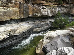
Porcupine Gorge is a gorge on Galah Creek in Porcupine Gorge National Park, North West Queensland, Australia. Access to the gorge and national park is via the Kennedy Development Road.
The sandstone gorge has incised up to 40 m below the adjacent plateau surface. In winter the base of the gorge is a series of waterholes while in the wet season it becomes a raging cascade which has excavated a deep chasm.
There is an annual race held in the gorge called the Porcupine Gorge Challenge. It starts at the bottom of the gorge at The Pyramid.
The gorge is a natural attraction for a diverse array of birdlife.
Stratigraphy
Betts Creek Beds
The Betts Creek Beds are located at the far end of the study area and are quite a small unit. The lower section is primarily interbedded siltstone and mudstone with coal seams formed within these layers. The coal itself is sub-bituminous and has well defined cleats with an overall waxy texture. Above these are larger mudstone beds which have well preserved fossil leaves of Glossopteris fauna, this is a clear Permian indicator and gives a good indication of the source of organic matter needed for coal formation.
Above these are sandstone beds with very clear channelization, the layers also have well defined load structures. Then proceeding upwards, the rest of the Betts Creek Beds is dominated by coarser grained sandstone with intermittent mudstone beds every few meters.
A normal fault cuts through the sandstone units and releases hydrothermal fluids, the way this is seen is that the sandstone present in the hanging wall is much whiter than the sandstone present in the footwall. The reasoning for this is that when the spring created by the fault released hydrothermal fluids into the system, the oxidizing iron(II) in the sandstone was leached into the fluid and transported elsewhere. On the footwall the iron(II) has not been transported away during the fault release. The fault has also produced a fault breccia culminating in downstream accretion with large clasts, indicating a high flow regime at the time of faulting.
From the lithology and structures present the system is thought to have originally begun as a swamp area with plenty of Glossopteris dying and producing an anaerobic system to produce the kerogen necessary. After time progresses, the system is flooded with sand moving with flooding waters. From this we know that the swamp area was close to the coastline, and then due to sea level rise in the area, flooded over burying the kerogen.
...
Wikipedia
