Port Nolloth
| Port Nolloth | |
|---|---|

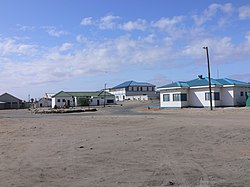
Port Nolloth town, 2005
|
|
|
|
|
| Coordinates: 29°15′S 16°52′E / 29.250°S 16.867°ECoordinates: 29°15′S 16°52′E / 29.250°S 16.867°E | |
| Country | South Africa |
| Province | Northern Cape |
| District | Namakwa |
| Municipality | Richtersveld |
| Established | 1854 |
| Area | |
| • Total | 30.32 km2 (11.71 sq mi) |
| Population (2011) | |
| • Total | 6,092 |
| • Density | 200/km2 (520/sq mi) |
| Racial makeup (2011) | |
| • Black African | 16.2% |
| • Coloured | 72.0% |
| • Indian/Asian | 0.6% |
| • White | 10.2% |
| • Other | 1.0% |
| First languages (2011) | |
| • Afrikaans | 85.2% |
| • Xhosa | 7.0% |
| • English | 3.5% |
| • Sotho | 1.1% |
| • Other | 3.1% |
| Postal code (street) | 8280 |
| PO box | 8280 |
| Area code | 027 |
Port Nolloth is a town and small domestic seaport in the Namaqualand region on the northwestern coast of South Africa, 144 kilometres (89 mi) northwest of Springbok. It is the seat of the Richtersveld Local Municipality.
The port was previously a transshipment point for copper from the Okiep mines, and diamonds from the Namaqua coast. Since the 1970s the principal seagoing activities have been fishing and small-vessel tourism. Today the town is a sleepy commercial hub with a number of holiday homes and a caravan park at the adjacent McDougalls Bay. It is also a gateway to the Richtersveld National Park, located 160 kilometres (99 mi) to the north along the Orange River.
The cold Benguela Current in the Atlantic Ocean off the west coast of South Africa moderates the climate of the coastal region to a huge degree. The average daily maximum throughout the year is only just above 20 degrees Celsius (68 degrees Fahrenheit) with a variation of less than 4 degrees between the hottest and coldest months of the year at Port Nolloth. On average the temperature reaches 30 degrees Celsius (86 degrees Fahrenheit) on only 15 days per year, compared to an average of 220 days per year at Vioolsdrif, less than 100 kilometres (62 mi) to the north-east. The west coast is regularly frequented by a thick fog bank rolling in from the cold ocean, a phenomenon locally known as the Malmokkie.
Port Nolloth is located in the southern part of the Namib desert and on average receives barely 50 mm (2 inches) of precipitation per year.
The bay upon which the port sits was known by the indigenous Namaqua people as Aukwatowa ("Where the water took away the old man"). Its location was marked by Portuguese explorer Bartolomeu Dias on his epic voyage around the Cape of Good Hope in 1487. It was the last landfall he sighted before a wild storm blew his ship off course and out to sea for 13 days.
...
Wikipedia


