Pulaski County, Missouri
| Pulaski County, Missouri | |
|---|---|

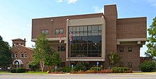
Old and new Pulaski County courthouses in Waynesville
|
|
 Location in the U.S. state of Missouri |
|
 Missouri's location in the U.S. |
|
| Founded | January 19, 1833 |
| Named for | Kazimierz Pułaski |
| Seat | Waynesville |
| Largest community | Fort Leonard Wood |
| Area | |
| • Total | 551 sq mi (1,427 km2) |
| • Land | 547 sq mi (1,417 km2) |
| • Water | 4.4 sq mi (11 km2), 0.8% |
| Population (est.) | |
| • (2015) | 53,221 |
| • Density | 96/sq mi (37/km²) |
| Congressional district | 4th |
| Time zone | Central: UTC-6/-5 |
| Website | www |
| Pulaski County, Missouri | ||||
|---|---|---|---|---|
| Elected countywide officials | ||||
| Assessor | Dan Whittle | Republican | ||
| Circuit Clerk | Rachelle Beasley | Democratic | ||
| County Clerk | Brent Bassett | Republican | ||
| Collector | Terri Mitchell | Republican | ||
|
Commissioner (Presiding) |
Gene Newkirk | Republican | ||
|
Commissioner (District 1) |
Lynn Sharp | Republican | ||
|
Commissioner (District 2) |
Ricky Zweerink | Republican | ||
| Coroner | Michael Hartness | Democratic | ||
| Prosecuting Attorney | Kevin Hillman | Republican | ||
| Public Administrator | Loretta Rouse | Republican | ||
| Recorder | Rachelle Beasley | Democratic | ||
| Sheriff | Ron Long | Republican | ||
| Surveyor | Don Mayhew | Republican | ||
| Treasurer | Sue Rapone | Republican | ||
| Pulaski County, Missouri | ||
|---|---|---|
| 2008 Republican primary in Missouri | ||
| John McCain | 1,129 (36.19%) | |
| Mike Huckabee | 1,216 (38.97%) | |
| Mitt Romney | 641 (20.54%) | |
| Ron Paul | 66 (2.12%) | |
| Pulaski County, Missouri | ||
|---|---|---|
| 2008 Democratic primary in Missouri | ||
| Hillary Clinton | 1,385 (56.07%) | |
| Barack Obama | 972 (39.35%) | |
| John Edwards (withdrawn) | 78 (3.16%) | |
Pulaski County is a county located in the U.S. state of Missouri. As of the 2010 census, the population was 52,274. Its county seat is Waynesville. The county was organized in 1833 and named for Kazimierz Pułaski, a Polish patriot who died fighting in the American Revolution.
Pulaski County is the site of Fort Leonard Wood, a U.S. Army installation base. It comprises the Fort Leonard Wood, MO Micropolitan Statistical Area.
Pulaski County's earliest settlers were the Quapaw, Missouria and Osage Native Americans. After the Lewis and Clark Expedition of the early 19th century, white settlers came to the area, many from Kentucky, Tennessee and the Carolinas; the earliest pioneers appeared to have settled as early as 1818, and the town of Waynesville was designated the county seat by the Missouri Legislature in 1833. Like the county, Waynesville is also named after an American Revolutionary hero, Mad Anthony Wayne.
According to the U.S. Census Bureau, the county has a total area of 551 square miles (1,430 km2), of which 547 square miles (1,420 km2) is land and 4.4 square miles (11 km2) (0.8%) is water.
As of the census of 2000, there were 41,165 people, 13,433 households, and 9,953 families residing in the county. The population density was 75 people per square mile (29/km²). There were 15,408 housing units at an average density of 28 per square mile (11/km²). The racial makeup of the county was 78.35% White, 11.99% Black or African American, 1.00% Native American, 2.27% Asian, 0.32% Pacific Islander, 2.50% from other races, and 3.57% from two or more races. Approximately 5.84% of the population were Hispanic or Latino of any race.
...
Wikipedia
