Randolph, Iowa
| Randolph, Iowa | |
|---|---|
| City | |
 |
|
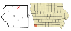
 Location of Randolph, Iowa |
|
| Coordinates: 40°52′23″N 95°34′0″W / 40.87306°N 95.56667°WCoordinates: 40°52′23″N 95°34′0″W / 40.87306°N 95.56667°W | |
| Country |
|
| State |
|
| County | Fremont |
| Area | |
| • Total | 0.32 sq mi (0.83 km2) |
| • Land | 0.32 sq mi (0.83 km2) |
| • Water | 0 sq mi (0 km2) |
| Elevation | 978 ft (298 m) |
| Population (2010) | |
| • Total | 168 |
| • Estimate (2016) | 154 |
| • Density | 525/sq mi (202.7/km2) |
| Time zone | Central (CST) (UTC-6) |
| • Summer (DST) | CDT (UTC-5) |
| ZIP code | 51649 |
| Area code(s) | 712 |
| FIPS code | 19-65640 |
| GNIS feature ID | 0460522 |
Randolph is a city in Fremont County, Iowa, United States. The population was 168 at the 2010 census. It is the birthplace of Virginia Smith, Republican U.S. representative from the 3rd District of Nebraska from 1975 until 1991.
Randolph was platted 1877 shortly before the completion of the railroad through that territory.
Randolph is located at 40°52′23″N 95°34′0″W / 40.87306°N 95.56667°W (40.872924, -95.566798) at the junction of Deer Creek and the West Nishnabotna River.
According to the United States Census Bureau, the city has a total area of 0.32 square miles (0.83 km2), all of it land.
As of the census of 2010, there were 168 people, 72 households, and 50 families residing in the city. The population density was 525.0 inhabitants per square mile (202.7/km2). There were 85 housing units at an average density of 265.6 per square mile (102.5/km2). The racial makeup of the city was 98.2% White, 0.6% African American, and 1.2% from two or more races. Hispanic or Latino of any race were 0.6% of the population.
...
Wikipedia
