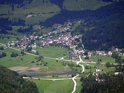
Rateče
| Rateče | |
|---|---|

Rateče, view from Mt. Ciprnik (July 2016)
|
|
| Location in Slovenia | |
| Coordinates: 46°29′53″N 13°42′58″E / 46.49806°N 13.71611°ECoordinates: 46°29′53″N 13°42′58″E / 46.49806°N 13.71611°E | |
| Country |
|
| Traditional region | Upper Carniola |
| Statistical region | Upper Carniola |
| Municipality | Kranjska Gora |
| Elevation | 863.6 m (2,833.3 ft) |
| Population (2002) | |
| • Total | 639 |
| Rateče | ||||||||||||||||||||||||||||||||||||||||||||||||||||||||||||
|---|---|---|---|---|---|---|---|---|---|---|---|---|---|---|---|---|---|---|---|---|---|---|---|---|---|---|---|---|---|---|---|---|---|---|---|---|---|---|---|---|---|---|---|---|---|---|---|---|---|---|---|---|---|---|---|---|---|---|---|---|
| Climate chart () | ||||||||||||||||||||||||||||||||||||||||||||||||||||||||||||
|
||||||||||||||||||||||||||||||||||||||||||||||||||||||||||||
|
||||||||||||||||||||||||||||||||||||||||||||||||||||||||||||
| J | F | M | A | M | J | J | A | S | O | N | D |
|
43
2
−7
|
43
5
−7
|
61
9
−3
|
103
13
1
|
107
18
5
|
146
21
9
|
152
23
10
|
129
24
11
|
158
18
7
|
224
13
3
|
194
6
−2
|
91
1
−6
|
| Average max. and min. temperatures in °C | |||||||||||
| Precipitation totals in mm | |||||||||||
| Source: [1] | |||||||||||
| Imperial conversion | |||||||||||
|---|---|---|---|---|---|---|---|---|---|---|---|
| J | F | M | A | M | J | J | A | S | O | N | D |
|
1.7
36
19
|
1.7
41
19
|
2.4
48
27
|
4.1
55
34
|
4.2
64
41
|
5.7
70
48
|
6
73
50
|
5.1
75
52
|
6.2
64
45
|
8.8
55
37
|
7.6
43
28
|
3.6
34
21
|
| Average max. and min. temperatures in °F | |||||||||||
| Precipitation totals in inches | |||||||||||
...
Wikipedia

