Raymondville, Texas
| Raymondville, Texas | |
|---|---|
| City | |
| City of Raymondville | |
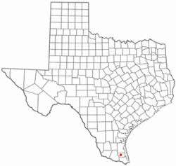
 Location of Raymondville, Texas |
|
 |
|
| Coordinates: 26°28′53″N 97°46′59″W / 26.48139°N 97.78306°WCoordinates: 26°28′53″N 97°46′59″W / 26.48139°N 97.78306°W | |
| Country | United States |
| State | Texas |
| County | Willacy |
| Area | |
| • Total | 3.8 sq mi (9.8 km2) |
| • Land | 3.8 sq mi (9.8 km2) |
| • Water | 0.0 sq mi (0.0 km2) |
| Elevation | 30 ft (9 m) |
| Population (2010) | |
| • Total | 11,284 |
| • Density | 3,000/sq mi (1,200/km2) |
| Time zone | Central (CST) (UTC-6) |
| • Summer (DST) | CDT (UTC-5) |
| ZIP codes | 78580, 78598 |
| Area code(s) | 956 |
| FIPS code | 48-60836 |
| GNIS feature ID | 1377181 |
Raymondville is a city in and the county seat of Willacy County, Texas, United States. The population was 11,284 at the 2010 census. It may be included as part of the Brownsville–Harlingen–Raymondville and the Matamoros–Brownsville metropolitan areas.
Raymondville was formed in 1904 by Edward Burleson Raymond, a foreman of the El Sauz Ranch portion of the King Ranch and owner of the Las Majadas Ranch.
Raymondville is located at 26°28′53″N 97°46′59″W / 26.48139°N 97.78306°W (26.481464, -97.783013) and is known as the "Gateway to the Rio Grande Valley." According to the United States Census Bureau, the city has a total area of 3.8 square miles (9.8 km²), all of it land.
Soils are mostly clay or sandy clay loams which are well drained or moderately well drained. Some fine sandy loams underlie the eastern part of town. These have near neutral pH. Other parts of town have moderately alkaline, somewhat saline soils. Around the southern edge of town is an area of strong salinity which imposes limitations on farmers and gardeners.
The climate in this area is characterized by hot, humid summers and generally mild to cool winters. According to the Köppen Climate Classification system, Raymondville has a humid subtropical climate, abbreviated "Cfa" on climate maps.
...
Wikipedia
