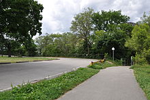
Raymore Drive
 |
|
| Maintained by | the City of Toronto |
|---|---|
| Length | 0.563 km (0.350 mi) Was formerly 0.929 km (0.577 mi), before it was washed away during Hurricane Hazel |
| West end | Scarlett Road in Toronto |
| East end | Raymore Park in Toronto |
Coordinates: 43°41′47.94″N 79°30′54.24″W / 43.6966500°N 79.5150667°W
Raymore Drive is a mostly residential street in the Weston neighbourhood of Toronto in the Canadian province of Ontario. It runs next to the Humber River. On October 15, 1954, the area was severely affected by Hurricane Hazel. When the Humber River burst its banks and tore away a footbridge, the waters of the Humber were redirected through the neighbourhood. The flood killed 35 residents and washed away 39 percent of the street. Altogether, Hazel was responsible for 81 deaths in Canada. Subsequent residential development in that area was prohibited. The properties were expropriated and made into Raymore Park.
Raymore Drive and Raymore Park are located on land which was owned by the Scarlett family, the namesake for Scarlett Road, until the mid-1850s. In 1857, Rowland Burr, a local businessman, proposed to build a canal between Lake Ontario and Georgian Bay on Lake Huron, which would have used part of the Humber River where it passes Raymore Drive. This project was not completed, and instead the Trent Canal, which links Lake Huron at Severn to Lake Ontario at Trenton, roughly 150 km (93 mi) to the northeast, was built to serve the purpose.
...
Wikipedia
