River Somme
| Somme (La Somme) | |
|
The Somme
|
|
| Country | France |
|---|---|
| Region | Picardy |
| Source | |
| - location | Fonsommes |
| - elevation | 85 m (279 ft) |
| - coordinates | 49°54′22″N 3°24′11″E / 49.906°N 3.403°E |
| Mouth | |
| - location |
Saint-Valery-sur-Somme English Channel |
| - coordinates | 50°11′12″N 1°38′35″E / 50.1867°N 1.6431°ECoordinates: 50°11′12″N 1°38′35″E / 50.1867°N 1.6431°E |
| Length | 245 km (152 mi) |
| Basin | 6,550 km2 (2,529 sq mi) |
| Discharge | for Abbeville |
| - average | 35 m3/s (1,236 cu ft/s) |
|
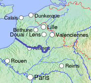
Topographic map of the Somme basin
|
|
The Somme is a river in Picardy, northern France. The name Somme comes from a Celtic word meaning "tranquility". The department Somme was named after this river.
The river is 245 km (152 mi) long, from its source in the high ground of the former Forest of Arrouaise at Fonsommes near Saint-Quentin, to the Bay of the Somme, in the English Channel. It lies in the geological syncline which also forms the Solent. This gives it a fairly constant and gentle gradient where several fluvial terraces have been identified.
The river is characterized by a very gentle gradient and a steady flow. The valley is more or less steep-sided but its bottom is flat with fens and pools. These characteristics of steady flow and flooded valley bottom arise from the river's being fed by the ground water in the chalk basin in which it lies. At earlier, colder times, from the Günz to the Würm (Beestonian or Nebraskan to Devensian or Wisconsinian) the river has cut down into the Cretaceous geology to a level below the modern water table. The valley bottom has now therefore, filled with water which, in turn, has filled with fen. , of the source of the Somme in 1986, shows it when the water table had fallen below the surface of the chalk in which the aquifer lies. Here, the flow of water had been sufficient to keep fen from forming.
...
Wikipedia


