Rocky Hill, New Jersey
| Rocky Hill, New Jersey | |
|---|---|
| Borough | |
| Borough of Rocky Hill | |

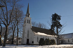
First Reformed Church, built 1856, at the heart of the Rocky Hill Historic District
|
|
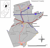
 Map of Rocky Hill in Somerset County. Inset: Location of Somerset County highlighted in the State of New Jersey. |
|
 Census Bureau map of Rocky Hill, New Jersey |
|
| Coordinates: 40°24′01″N 74°38′20″W / 40.400348°N 74.638922°WCoordinates: 40°24′01″N 74°38′20″W / 40.400348°N 74.638922°W | |
| Country |
|
| State |
|
| County | Somerset |
| Incorporated | December 18, 1889 |
| Government | |
| • Type | Borough |
| • Body | Borough Council |
| • Mayor | Jeff Donahue (I, term ends December 31, 2018) |
| • Clerk | Rebecca P. Newman |
| Area | |
| • Total | 0.622 sq mi (1.612 km2) |
| • Land | 0.619 sq mi (1.604 km2) |
| • Water | 0.003 sq mi (0.008 km2) 0.52% |
| Area rank | 537th of 566 in state 21st of 21 in county |
| Elevation | 108 ft (33 m) |
| Population (2010 Census) | |
| • Total | 682 |
| • Estimate (2015) | 690 |
| • Rank | 548th of 566 in state 20th of 21 in county |
| • Density | 1,101.4/sq mi (425.3/km2) |
| • Density rank | 370th of 566 in state 11th of 21 in county |
| Time zone | Eastern (EST) (UTC-5) |
| • Summer (DST) | Eastern (EDT) (UTC-4) |
| ZIP code | 08553 |
| Area code(s) | 609 Exchanges: 252, 279, 430, 921, 924 |
| FIPS code | 3403564320 |
| GNIS feature ID | 0885376 |
| Website | www |
Rocky Hill is a borough in Somerset County, New Jersey, United States, named for the Rocky Hill Ridge. It was earlier known as the Devil's Featherbed because it was difficult to travel the rocky terrain by horse and wagon. As of the 2010 United States Census, the borough's population was 682, reflecting an increase of 20 (+3.0%) from the 662 counted in the 2000 Census, which had in turn declined by 31 (-4.5%) from the 693 counted in the 1990 Census.
Rocky Hill was incorporated as a borough by an act of the New Jersey Legislature on December 18, 1889, from portions of Montgomery Township, based on the results of a referendum held four days earlier.
According to the United States Census Bureau, the borough had a total area of 0.622 square miles (1.612 km2), including 0.619 square miles (1.604 km2) of land and 0.003 square miles (0.008 km2) of water (0.52%).
The borough borders the Somerset County municipalities of Franklin Township and Montgomery Township.
The 2010 United States Census counted 682 people, 280 households, and 189 families residing in the borough. The population density was 1,101.4 per square mile (425.3/km2). The borough contained 292 housing units at an average density of 471.6 per square mile (182.1/km2). The racial makeup of the borough was 91.64% (625) White, 1.47% (10) Black or African American, 0.00% (0) Native American, 2.35% (16) Asian, 0.00% (0) Pacific Islander, 1.47% (10) from other races, and 3.08% (21) from two or more races. Hispanics or Latinos of any race were 4.84% (33) of the population.
...
Wikipedia
