Rossville, Indiana
| Rossville, Indiana | |
|---|---|
| Town | |

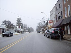
Westbound along Main Street in downtown Rossville
|
|
| Motto: "Where You Feel At Home" | |
 Location of Rossville in the state of Indiana |
|
| Coordinates: 40°25′9″N 86°35′47″W / 40.41917°N 86.59639°WCoordinates: 40°25′9″N 86°35′47″W / 40.41917°N 86.59639°W | |
| Country | United States |
| State | Indiana |
| County | Clinton |
| Township | Ross |
| Founded | 1832 |
| Incorporated | 1870 |
| Named for | John Ross, settler |
| Area | |
| • Total | 0.53 sq mi (1.37 km2) |
| • Land | 0.53 sq mi (1.37 km2) |
| • Water | 0 sq mi (0 km2) |
| Elevation | 725 ft (221 m) |
| Population (2010) | |
| • Total | 1,653 |
| • Estimate (2012) | 1,648 |
| • Density | 3,118.9/sq mi (1,204.2/km2) |
| Time zone | Eastern (EST) (UTC-5) |
| • Summer (DST) | EDT (UTC-4) |
| ZIP code | 46065 |
| Area code(s) | 765 |
| FIPS code | 18-66150 |
| GNIS feature ID | 0442329 |
| Website | www |
Rossville is a town in Ross Township, Clinton County, Indiana, United States. The population was 1,653 at the 2010 census.
In 1832, Thomas Ewing, with his wife and infant child, settled on 160 acres (0.65 km2) of land north of what is now Main Street in Rossville. In 1834, Ewing and Thomas Smith platted the town of Rossville with the intention of starting a blacksmith shop at the location. The town grew steadily and gained a store operated by William Seawright, a saddler (John H. Smith) and a physician (Dr. James Wilson). Residents of Rossville are also referred to as "Rossvillians".
A petition to incorporate the town was filed on October 22, 1870, at which time the town had 339 residents and 66 families. The incorporation election, held November 5, passed with a vote of 35 to 19 and on December 1, 1870, Rossville was incorporated. The town is named for John Ross, a pioneer settler and associate county judge.
The Monon Railroad was completed through Rossville in 1883.
Rossville is located at 40°25′9″N 86°35′47″W / 40.41917°N 86.59639°W (40.419138, -86.596466).
According to the 2010 census, Rossville has a total area of 0.52 square miles (1.35 km2), all land.
As of the census of 2010, there were 1,653 people, 611 households, and 451 families residing in the town. The population density was 3,118.9 inhabitants per square mile (1,204.2/km2). There were 652 housing units at an average density of 1,230.2 per square mile (475.0/km2). The racial makeup of the town was 97.5% White, 0.4% African American, 0.2% Native American, 0.5% Asian, 0.6% from other races, and 0.8% from two or more races. Hispanic or Latino of any race were 0.8% of the population.
...
Wikipedia
