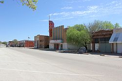
Rotan, Texas
| Rotan, Texas | |
|---|---|
| City | |

Rotan, Texas
|
|
| Coordinates: 32°51′19″N 100°27′54″W / 32.85528°N 100.46500°WCoordinates: 32°51′19″N 100°27′54″W / 32.85528°N 100.46500°W | |
| Country | United States |
| State | Texas |
| County | Fisher |
| Area | |
| • Total | 2.02 sq mi (5.24 km2) |
| • Land | 2.02 sq mi (5.24 km2) |
| • Water | 0.0 sq mi (0.0 km2) |
| Elevation | 1,949 ft (594 m) |
| Population (2010) | |
| • Total | 1,508 |
| • Density | 746/sq mi (287.9/km2) |
| Time zone | Central (CST) (UTC-6) |
| • Summer (DST) | CDT (UTC-5) |
| ZIP code | 79546 |
| Area code(s) | 325 |
| FIPS code | 48-63464 |
| GNIS feature ID | 1345626 |
Rotan (/roʊˈtæn/; roh-TAN) is a city in Fisher County, Texas, United States. The population was 1,508 at the 2010 census, down from 1,611 at the 2000 census.
Texas State Highway 70 passes through the city, leading north 34 miles (55 km) to Jayton and south 9 miles (14 km) to Roby, the Fisher County seat, and 30 miles (48 km) to Sweetwater and Interstate 20. Texas State Highway 92 leads east from Rotan 20 miles (32 km) to Hamlin.
According to the United States Census Bureau, Rotan has a total area of 2.0 square miles (5.2 km2), all of it land.
As of the census of 2000, there were 1,611 people, 665 households, and 442 families residing in the city. The population density was 791.3 people per square mile (304.9/km²). There were 841 housing units at an average density of 413.1 per square mile (159.2/km²). The racial makeup of the city was 72.44% White, 5.59% African American, 0.25% Native American, 0.19% Asian, 19.49% from other races, and 2.05% from two or more races. Hispanic or Latino of any race were 32.90% of the population.
...
Wikipedia


