Rotterdam, New York
| Rotterdam, New York | |
|---|---|
| Town | |

A sign depicting the entrance to town of Rotterdam on New York State Route 5
|
|
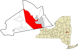
 Location in Schenectady County and the state of New York. |
|
| Coordinates: 42°47′12″N 73°58′15″W / 42.78667°N 73.97083°WCoordinates: 42°47′12″N 73°58′15″W / 42.78667°N 73.97083°W | |
| Country | United States |
| State | New York |
| County | Schenectady |
| Settled | 1661 |
| Established | 1820 |
| Named for | Rotterdam, Netherlands |
| Government | |
| • Supervisor | Steven Tommasone |
| Area | |
| • Total | 36.4 sq mi (94.4 km2) |
| • Land | 35.7 sq mi (92.4 km2) |
| • Water | 0.8 sq mi (2.0 km2) |
| Elevation | 512 ft (156 m) |
| Population (2010) | |
| • Total | 29,094 |
| • Density | 800/sq mi (310/km2) |
| Time zone | Eastern (EST) (UTC-5) |
| • Summer (DST) | (EDT) (UTC-4) |
| ZIP code | 12306 or 12303 |
| Area code(s) | 518 |
| FIPS code | 36-63935 |
| GNIS feature ID | 979437 |
| Website | www |
Rotterdam is a town in Schenectady County, New York, United States. The population was 29,094 at the 2010 census.
The town of Rotterdam is in the south-central part of the county. It was founded by Dutch settlers, who named it after the port of Rotterdam in the Netherlands, where many immigrants last touched European grounds. The town borders the city of Schenectady.
Situated near the eastern end of New York State's Heritage Corridor at what is known as the "Gateway to the West", the town of Rotterdam is closely linked with the early development of Schenectady. At that time the present town of Rotterdam served as the outlying farmlands and wood lots for the settlers. With few exceptions, these settlers made their homes in the stockade in Schenectady but went to their farmlands during the daytime.
The lands now known as Rotterdam became Schenectady's third ward when that city was incorporated in 1798. Rotterdam retained that status when the county of Schenectady was chartered in 1809. During this period, a council of aldermen and assistants from each of the four wards governed the city of Schenectady. In May 1819, the city council recommended that the third and fourth wards be separated out as towns, and on December 31, a petition to the state legislature was drafted. The legislation was passed on April 14, 1820, the final day of the legislative session, creating the town of Rotterdam.
The Dellemont-Wemple Farm was added to the National Register of Historic Places in 1973, and the Enlarged Double Lock No. 23, Old Erie Canal in 2008.
The Mabee House, at the Mabee Farm Historic Site, the oldest surviving house in the Mohawk Valley, was added to the National Register of Historic Places May 22, 1978. It is a property of the Schenectady County Historical Society, being donated by a last descendant in his particular line, Mr. George Eugene Franchere, on January 29, 1993, the 287th anniversary of the original deed. It is currently being operated as a living history museum, conducts school programs, and events for the public.
...
Wikipedia
