Russell Ranch Oil Field
| Russell Ranch Oil Field | |
|---|---|

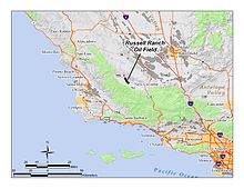
The Russell Ranch Oil Field in central and southern California. Other oil fields are shown in dark gray.
|
|
| Country | United States |
| Region | Cuyama Valley |
| Location | Santa Barbara and San Luis Obispo County, California |
| Offshore/onshore | onshore |
| Operator | E&B Natural Resources |
| Field history | |
| Discovery | 1948 |
| Start of development | 1948 |
| Start of production | 1948 |
| Peak year | 1950 |
| Production | |
| Current production of oil | 113.4 barrels per day (~5,651 t/a) |
| Estimated oil in place | 0.216 million barrels (~29,500 t) |
| Producing formations | Santa Margarita Formation (late Miocene); Vaqueros Sandstone (early Miocene) |
The Russell Ranch Oil Field is an oil and gas field in the Cuyama Valley of northern Santa Barbara and southern San Luis Obispo Counties, California, in the United States. Discovered in 1948, and reaching peak production in 1950, it has produced over 68 million barrels (10,800,000 m3) of oil in its lifetime; with only an estimated 216,000 barrels (34,300 m3) of recoverable oil remaining, and having produced around 66,000 in 2008, it is considered to be close to exhaustion. The primary operator on the field as of 2010 is E&B Natural Resources, which also runs the nearby South Cuyama Oil Field.
The oil field one of the two significant fields in the Cuyama Valley, the other being the much larger South Cuyama Oil Field. The Russell Ranch field is about seven miles (11 km) west-northwest of the town of New Cuyama. The total productive area is about 1,540 acres (6.2 km2), and the field is about five miles (8 km) long by one-half mile across, with the long axis trending approximately northwest to southeast, beginning at Whiterock Bluff in the Caliente Range, crossing under the Cuyama River, and ending in the foothills of the Sierra Madre Mountains. The Cuyama River, and California State Route 166 which parallels the river, cut through the center of the field; travelers on Route 166 have a brief view of oil storage tanks and several pumpjacks, but most of the oilfield operations are out of sight from the public right-of-way.
Elevations on the field range from around 1,750 feet (530 m) where the river cuts across the field, to around 2,200 feet (670 m) at the southern end in the hills. Terrain consists of an alluvial plain around the river, and grass- and brush-covered hills, cut by numerous gullies and badlands, at both ends of the field in the lower portion of the Caliente and Sierra Madre mountains. Climate is Mediterranean, but modified by the distance from the coast; winters are colder, with occasional freezes, and summertime temperatures sometimes top 100 °F (38 °C). Drainage is to the Cuyama River, which flows out to the ocean at Guadalupe. In the vicinity of the oil field, the predominant land use, aside from activities associated with oil production and storage, is cattle grazing. The bottomlands of the Cuyama Valley, adjacent to the field on the east-southeast, are primarily agricultural.
...
Wikipedia
