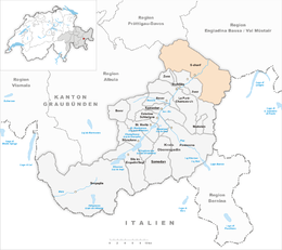
S-chanf
| S-chanf | ||
|---|---|---|
 |
||
|
||
| Coordinates: 46°37′N 9°59′E / 46.617°N 9.983°ECoordinates: 46°37′N 9°59′E / 46.617°N 9.983°E | ||
| Country | Switzerland | |
| Canton | Graubünden | |
| District | Maloja | |
| Area | ||
| • Total | 138.04 km2 (53.30 sq mi) | |
| Elevation | 1,660 m (5,450 ft) | |
| Population (Dec 2015) | ||
| • Total | 697 | |
| • Density | 5.0/km2 (13/sq mi) | |
| Postal code | 7525 | |
| SFOS number | 3788 | |
| Surrounded by | Bergün/Bravuogn, Davos, Livigno (IT-SO), Madulain, Susch, Zernez, Zuoz | |
| Website |
www SFSO statistics |
|
S-chanf (![]() [ʃtɕaɱf] ; German: Scanfs; Italian: Scanevo) is a municipality in the district of Maloja in the Swiss canton of Graubünden.
[ʃtɕaɱf] ; German: Scanfs; Italian: Scanevo) is a municipality in the district of Maloja in the Swiss canton of Graubünden.
Localities in S-chanf municipality include Susauna, Chapella and Cinuos-chel.
S-chanf is first mentioned around 1137-39 as Scaneves. In 1356 it was mentioned as Scanevo. The Romansh name S-chanf is pronounced [ʃtɕanf]. The German Scanfs was official until 1943. Chapella is the site of a chapel mentioned in 1209. Susauna is mentioned as Sauzana in 1285.
S-chanf has an area, as of 2006[update], of 138 km2 (53 sq mi). Of this area, 23.7% is used for agricultural purposes, while 18.6% is forested. Of the rest of the land, 0.6% is settled (buildings or roads) and the remainder (57.1%) is non-productive (rivers, glaciers or mountains).
The municipality is located in the Oberengadin sub-district of the Maloja district along the Inn river and at the mouth of the Casanna pass. It consists of the linear village of S-chanf with the sections of Cinuos-chel and Susauna. The village elevation is 1,662 meters (5,453 ft).
...
Wikipedia


