Saint-Benoît-Labre, Quebec
| Saint-Benoît-Labre | |
|---|---|
| Municipality | |
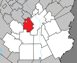
 Location within Beauce-Sartigan RCM. |
|
| Location in southern Quebec. | |
| Coordinates: 46°04′N 70°48′W / 46.067°N 70.800°WCoordinates: 46°04′N 70°48′W / 46.067°N 70.800°W | |
| Country |
|
| Province |
|
| Region | Chaudière-Appalaches |
| RCM | Beauce-Sartigan |
| Constituted | January 4, 1894 |
| Government | |
| • Mayor | Marco Marois |
| • Federal riding | Beauce |
| • Prov. riding | Beauce-Sud |
| Area | |
| • Total | 86.90 km2 (33.55 sq mi) |
| • Land | 84.99 km2 (32.81 sq mi) |
| Population (2011) | |
| • Total | 1,612 |
| • Density | 19.0/km2 (49/sq mi) |
| • Pop 2006-2011 |
|
| • Dwellings | 735 |
| Time zone | EST (UTC−5) |
| • Summer (DST) | EDT (UTC−4) |
| Postal code(s) | G0M 1P0 |
| Area code(s) | 418 and 581 |
| Highways |
|
| Website | www |
Saint-Benoît-Labre is a municipality in the Municipalité régionale de comté de Beauce-Sartigan in Quebec, Canada. It is part of the Chaudière-Appalaches region and the population is 1,630 as of 2009. It is named after Benedict Joseph Labre.
Since 2001, a group of Cistercian nuns from Saint-Romuald, Quebec, moved to a newly constructed abbey in Saint-Benoît-Labre to make chocolate.
The territory of Saint-Benoît-Labre surrounds the village of Lac-Poulin.
...
Wikipedia

