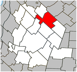
Saint-Hugues, Quebec
| Saint-Hugues | |
|---|---|
| Municipality | |
 Location within Les Maskoutains RCM. |
|
| Location in southern Quebec. | |
| Coordinates: 45°48′N 72°52′W / 45.800°N 72.867°WCoordinates: 45°48′N 72°52′W / 45.800°N 72.867°W | |
| Country |
|
| Province |
|
| Region | Montérégie |
| RCM | Les Maskoutains |
| Founded | 1827 |
| Constituted | November 6, 1982 |
| Government | |
| • Mayor | Serge Picard |
| • Federal riding | Saint-Hyacinthe—Bagot |
| • Prov. riding | Saint-Hyacinthe |
| Area | |
| • Total | 85.90 km2 (33.17 sq mi) |
| • Land | 83.84 km2 (32.37 sq mi) |
| Population (2011) | |
| • Total | 1,292 |
| • Density | 15.4/km2 (40/sq mi) |
| • Pop 2006-2011 |
|
| • Dwellings | 536 |
| Time zone | EST (UTC−5) |
| • Summer (DST) | EDT (UTC−4) |
| Postal code(s) | J0H 1N0 |
| Area code(s) | 450 and 579 |
| Highways |
|
| Website | www |
Saint-Hugues (/ˌseɪnt ˈhjuːz/; French pronunciation: [sɛ̃.yɡ]) is a town in southwestern Quebec north northeast of St-Hyacinthe, with a 2006 population of 1,310. It is located along Quebec Route 224, halfway between Saint-Guillaume and Saint-Simon-de-Bagot.
In 1827 Saint-Hugues was created as a village, later to be incorporated into the county of Bagot.
...
Wikipedia

