Saint Arnaud, Victoria
|
St Arnaud Victoria |
|||||||||
|---|---|---|---|---|---|---|---|---|---|

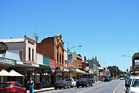
The Sunraysia Highway at St Arnaud
|
|||||||||
| Coordinates | 36°36′0″S 143°15′0″E / 36.60000°S 143.25000°ECoordinates: 36°36′0″S 143°15′0″E / 36.60000°S 143.25000°E | ||||||||
| Population | 2,193 (2016 census) | ||||||||
| Postcode(s) | 3478 | ||||||||
| Elevation | 240 m (787 ft) | ||||||||
| Location | |||||||||
| LGA(s) | Shire of Northern Grampians | ||||||||
| State electorate(s) | Ripon | ||||||||
| Federal Division(s) | Mallee | ||||||||
|
|||||||||
St Arnaud (/ˌsænt
It is named after French marshal Jacques Leroy de Saint Arnaud, commander-in-chief of the army of the East. It is one of quite a number of towns, streets etc. named after people and places of the Crimean War.
St Arnaud is a former gold mining town, situated on the main route between Ballarat and Mildura. The town was settled in the mid-1850s, the post office opening on 1 February 1856.
The town features many well-preserved historic buildings which line the main thoroughfare of Napier Street, including a generous collection of pubs. A number of attractive gardens exist in town, including Pioneer Park (believed to be Australia's only remaining public park designed by Edna Walling), the Queen Mary Botanic Gardens, the Market Square gardens adjacent to the council offices and Lord Nelson Park which offers sporting facilities as well as attractions such as the old Lord Nelson Mine and views from Wilsons Hill.
A short drive south of St Arnaud towards Avoca is the St Arnaud Range National Park, featuring steep and forested terrain, camp sites and the Teddington Reservoir.
...
Wikipedia

