Sainte-Opportune-du-Bosc
| Sainte-Opportune-du-Bosc | |
|---|---|
 |
|
| Coordinates: 49°09′42″N 0°50′17″E / 49.1617°N 0.8381°ECoordinates: 49°09′42″N 0°50′17″E / 49.1617°N 0.8381°E | |
| Country | France |
| Region | Normandy |
| Department | Eure |
| Arrondissement | Bernay |
| Canton | Beaumont-le-Roger |
| Intercommunality | Beaumont-le-Roger |
| Government | |
| • Mayor (2008–2014) | Simonne Pimont |
| Area1 | 8.07 km2 (3.12 sq mi) |
| Population (2008)2 | 628 |
| • Density | 78/km2 (200/sq mi) |
| Time zone | CET (UTC+1) |
| • Summer (DST) | CEST (UTC+2) |
| INSEE/Postal code | 27576 /27110 |
| Elevation | 97–150 m (318–492 ft) |
|
1 French Land Register data, which excludes lakes, ponds, glaciers > 1 km² (0.386 sq mi or 247 acres) and river estuaries. 2Population without double counting: residents of multiple communes (e.g., students and military personnel) only counted once. |
|
1 French Land Register data, which excludes lakes, ponds, glaciers > 1 km² (0.386 sq mi or 247 acres) and river estuaries.
Sainte-Opportune-du-Bosc is a commune in the Eure department in Haute-Normandie in northern France.
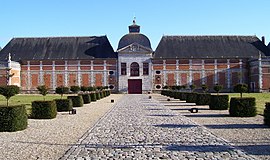
In 935 a big battle between William I, Duke of Normandy and Robert II took place near the town. The battlefield was called Champ-de-Bataille later and in the 17th century the Marshall of Créqui built a castle there.
The Château du Champ de Bataille was owned by the Harcourt family and has formal gardens designed by Le Nôtre.
Château du Champ-de-Bataille
Detail of the garden of the castle
...
Wikipedia


