Salem, Michigan
| Salem Township, Michigan | ||
|---|---|---|
| Township | ||

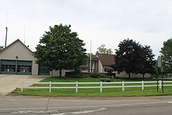
Township Hall, Six Mile & Salem Rds.
|
||
|
||
| Location within the state of Michigan | ||
| Coordinates: 42°24′N 83°36′W / 42.400°N 83.600°WCoordinates: 42°24′N 83°36′W / 42.400°N 83.600°W | ||
| Country | United States | |
| State | Michigan | |
| County | Washtenaw | |
| Area | ||
| • Total | 34.3 sq mi (88.8 km2) | |
| • Land | 34.3 sq mi (88.8 km2) | |
| • Water | 0.0 sq mi (0.0 km2) | |
| Elevation | 922 ft (281 m) | |
| Population (2010) | ||
| • Total | 5,627 | |
| • Density | 160/sq mi (63/km2) | |
| Time zone | Eastern (EST) (UTC-5) | |
| • Summer (DST) | EDT (UTC-4) | |
| ZIP code | 48175,48178,48105,48170,48167,48168 | |
| Area code(s) | 248, 734 | |
| FIPS code | 26-71130 | |
| GNIS feature ID | 1627035 | |
| Website | www |
|
Salem Township is a general law township of Washtenaw County in the U.S. state of Michigan, located northeast of Ann Arbor. At the 2010 census, the township population was 5,627.
According to the United States Census Bureau, the township has a total area of 34.3 square miles (88.8 km²), all land.
Salem is host to an Advanced Disposal-owned landfill, the Arbor Hills Landfill. The landfill was formerly owned by Veolia Environmental Services and is one of the largest landfills in the state. A large portion of revenue comes from Canadian trash kept in this landfill. Much of the revenue brought in by the landfill goes to the county government, and a smaller portion goes to the local government. Income generated from this landfill allows the township to levy no taxes for residents. This income also pays for government services including office staff and public safety. The current rate is between 24 and 28 mills total to the resident homeowner (depending on the school district).
ZIP codes:
School districts serving Salem Township:
At the 2000 census, there were 5,562 people, 1,928 households and 1,615 families residing in the township. The population density was 162.2 per square mile (62.6/km²). There were 2,031 housing units at an average density of 59.2 per square mile (22.9/km²). The racial makeup of the township was 95.97% White, 1.33% African American, 0.18% Native American, 0.68% Asian, 0.36% from other races, and 1.47% from two or more races. Hispanic or Latino of any race were 1.13% of the population.
...
Wikipedia


