San Gabriel mountains
| San Gabriel Mountains | |
|---|---|

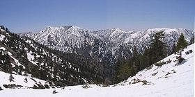
Summits in the eastern San Gabriel Mountains, Angeles National Forest, San Bernardino County, California. The main peaks are: Telegraph Peak, 8,985' (left), Cucamonga Peak, 8,859' (center), and Ontario Peak, 8693' (center right), as seen from Baldy Bowl on Mount Baldy.
|
|
| Highest point | |
| Peak | Mount San Antonio |
| Elevation | 10,064 ft (3,068 m) |
| Dimensions | |
| Length | 68.4 mi (110.1 km) |
| Width | 22.5 mi (36.2 km) |
| Area | 970 sq mi (2,500 km2) |
| Geography | |
| Country | United States |
| State | California |
| Counties | Los Angeles and San Bernardino |
| Range coordinates | 34°17′N 117°39′W / 34.29°N 117.65°WCoordinates: 34°17′N 117°39′W / 34.29°N 117.65°W |
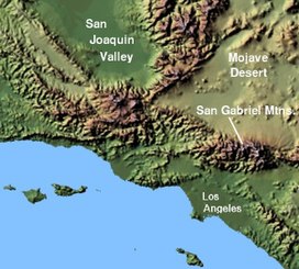
The San Gabriel Mountains are a mountain range located in northern Los Angeles County and western San Bernardino County, California, United States. The mountain range is part of the Transverse Ranges and lies between the Los Angeles Basin and the Mojave Desert, with Interstate 5 to the west and Interstate 15 to the east. This range lies in, and is surrounded by, the Angeles National Forest, with the San Andreas Fault as the northern border of the range.
The highest peak in the range is Mount San Antonio, commonly referred to as Mt. Baldy. Mount Wilson is another famous peak, famed for the Mount Wilson Observatory and the antenna farm that houses many of the transmitters for local media. The observatory may be visited by the public. On October 10, 2014, President Obama designated the area the San Gabriel Mountains National Monument.
Much of the range features rolling peaks. The range lacks craggy features, but contains a large number of canyons and is generally very rugged and difficult to traverse. The San Gabriel Mountains are in effect a large fault block that was uplifted and then dissected by numerous rivers and washes.
The highest elevation, Mount San Antonio at 10,064 feet (3,068 m), rises towards the eastern extremity of the range which extends from the Cajon Pass (Interstate 15 Freeway) on the east, where the San Gabriel Mountain Range meets the San Bernardino Mountain Range, westward to meet the Santa Susanna range at Newhall Pass (Interstate 5 Freeway).
...
Wikipedia

